NASA
Jet Propulsion Laboratory
California Institute of Technology
Skip Navigation
Ocean Surface Topography from Space
Stay Connected
menu
close modal
Resources
Jason-1 TRSR
Published:
September 13, 2010
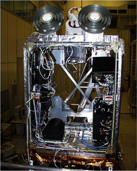
Jason-1 TRSR
ENLARGE
Related
OSTM/Jason-2 GPSP
OSTM/Jason-2 GPSP
TOPEX/Poseidon Artist's Concept
TOPEX/Poseidon Artist's Concept
The SpaceX Falcon 9 rocket carrying the Sentinel-6 Michael Freilich spacecraft lifts off from Space Launch Complex 4 at Vandenberg Air Force Base in California, Nov. 21, 2020, at 9:17 a.m. PST
Sentinel-6 Launch
Launch preparations are progressing! (11/21/01) Photos: Stacy Mitchell of John Hopkins APL/TIMED project
Launch preparations are progressing! (11/21/01) Photos: Stacy Mitchell of John Hopkins APL/TIMED project
SpaceX Falcon 9 rocket with the Sentinel-6 Michael Freilich satellite is lifted to vertical at Space Launch Complex 4
Sentinel-6 on pad at SLC-4, VAFB
Ocean Dynamic Topography
Ocean Dynamic Topography
Ariane 42P launch vehicle
Ariane 42P launch vehicle
TOPEX/Poseidon LRA
TOPEX/Poseidon LRA
Jason-3 Satellite Prepared For Launch
Jason-3 Satellite Prepared For Launch
The Antonov cargo aircraft carrying the Sentinel-6 Michael Freilich satellite touches down on the runway at Vandenberg Air Force Base in California on Sept. 24, 2020.
Sentinel-6 Spacecraft Arrival/Offload
Jason-1 launch images
Jason-1 launch images
These photos were taken during the Payload Attach Fitting (PAF) mating operation with Jason-1. (11/14/01) Photos: Scott Michel
These photos were taken during the Payload Attach Fitting (PAF) mating operation with Jason-1. (11/14/01) Photos: Scott Michel
Mike Davis in front of the faring
Mike Davis in front of the faring
Jason-1 launch images
Jason-1 launch images
OSTM/Jason-2 Artist's Concept
OSTM/Jason-2 Artist's Concept
The Antonov cargo aircraft carrying the Sentinel-6 Michael Freilich satellite touches down on the runway at Vandenberg Air Force Base in California on Sept. 24, 2020.
Sentinel-6 Spacecraft Arrival/Offload
Jason-1 readies for launch in its bay at Vandenberg, AFB (10/31/01)
Jason-1 readies for launch in its bay at Vandenberg, AFB (10/31/01)
Jason-3 on the Launch Pad
Jason-3 on the Launch Pad
This is an artist's concept of the Sentinel-6 Michael Freilich spacecraft.
Artist's concept of Sentinel-6 Michael Freilich
Jason-1 launch images
Jason-1 launch images
The SpaceX Falcon 9 rocket carrying the Sentinel-6 Michael Freilich spacecraft lifts off from Space Launch Complex 4 at Vandenberg Air Force Base in California, Nov. 21, 2020, at 9:17 a.m. PST
Sentinel-6 Launch
OSTM/Jason-2 Radiometer Antenna
OSTM/Jason-2 Radiometer Antenna
Inside half of the Delta Clam shell faring
Inside half of the Delta Clam shell faring
t - 7 minutes - Photo: Tom Shain
t - 7 minutes - Photo: Tom Shain
These photos were taken during the Dual Payload Attach Fitting (DPAF) mating operation with Jason-1. (11/13/01) Photos: Scott Michel
These photos were taken during the Dual Payload Attach Fitting (DPAF) mating operation with Jason-1. (11/13/01) Photos: Scott Michel