NASA
Jet Propulsion Laboratory
California Institute of Technology
Skip Navigation
Ocean Surface Topography from Space
Stay Connected
menu
close modal
Resources
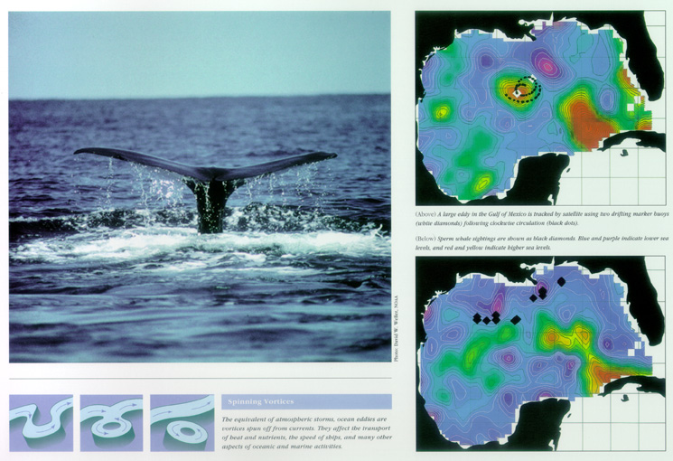
Whale Census and Habitat
Published:
September 13, 2010
Whale Census and Habitat
ENLARGE
Related
Launch preparations are progressing! (11/21/01) Photos: Stacy Mitchell of John Hopkins APL/TIMED project
Launch preparations are progressing! (11/21/01) Photos: Stacy Mitchell of John Hopkins APL/TIMED project
It’s not only water processes that play a role in global sea level rise – ground movements can play a significant role as well.
Rising Waters: Our Dynamic Earth
Sea Surface Height
Sea Surface Height
Ionospheric Total Electron Content
Ionospheric Total Electron Content
The Antonov cargo aircraft carrying the Sentinel-6 Michael Freilich satellite touches down on the runway at Vandenberg Air Force Base in California on Sept. 24, 2020.
Sentinel-6 Spacecraft Arrival/Offload
Jason-1 launch images
Jason-1 launch images
SpaceX Falcon 9 rocket with the Sentinel-6 Michael Freilich satellite is lifted to vertical at Space Launch Complex 4
Sentinel-6 on pad at SLC-4, VAFB
Launch preparations are progressing! (11/21/01) Photos: Stacy Mitchell of John Hopkins APL/TIMED project
Launch preparations are progressing! (11/21/01) Photos: Stacy Mitchell of John Hopkins APL/TIMED project
Jason-3 Lifts Off!
Jason-3 Lifts Off!
These photos were taken during the Payload Attach Fitting (PAF) mating operation with Jason-1. (11/14/01) Photos: Scott Michel
These photos were taken during the Payload Attach Fitting (PAF) mating operation with Jason-1. (11/14/01) Photos: Scott Michel
Jason-1 readies for launch in its bay at Vandenberg, AFB (10/31/01)
Jason-1 readies for launch in its bay at Vandenberg, AFB (10/31/01)
This artist's concept shows Jason-3 over the California coast.
Jason-3 over California
OSTM/Jason-2 GPSP
OSTM/Jason-2 GPSP
The SpaceX Falcon 9 rocket, topped with the Sentinel-6 Michael Freilich satellite secured inside its payload fairing, is rolled to Space Launch Complex 4
Sentinel-6 Rollout at SLC-4, VAFB
High Resolution Jason-1 launch images
High Resolution Jason-1 launch images
TOPEX/Poseidon Collecting Data
TOPEX/Poseidon Collecting Data
Launch preparations are progressing! (11/21/01) Photos: Stacy Mitchell of John Hopkins APL/TIMED project
Launch preparations are progressing! (11/21/01) Photos: Stacy Mitchell of John Hopkins APL/TIMED project
OSTM/Jason-2 Radiometer Antenna
OSTM/Jason-2 Radiometer Antenna
OSTM/Jason-2 Radiometer Antenna
OSTM/Jason-2 Radiometer Antenna
Applications of Spaceborne Altimetry
Applications of Spaceborne Altimetry
This illustration shows the Sentinel-6 Michael Freilich spacecraft in orbit above Earth with its deployable solar panels extended.
Sentinel-6 Michael Freilich Artist's Rendering
Jason-3
Jason-3
Jason-1 TRSR
Jason-1 TRSR
The SpaceX Falcon 9 with the Sentinel-6 Michael Freilich satellite is lifted to vertical at Space Launch Complex 4
Sentinel-6 on pad at SLC-4, VAFB
The Antonov cargo aircraft carrying the Sentinel-6 Michael Freilich satellite touches down on the runway at Vandenberg Air Force Base in California on Sept. 24, 2020.
Sentinel-6 Spacecraft Arrival/Offload