NASA
Jet Propulsion Laboratory
California Institute of Technology
Skip Navigation
Ocean Surface Topography from Space
Stay Connected
menu
close modal
Resources
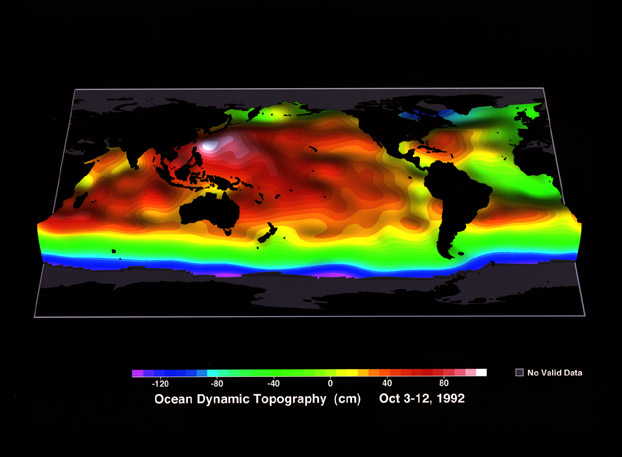
Ocean Dynamic Topography
Published:
September 13, 2010
Ocean Dynamic Topography
ENLARGE
Related
Jason-3 Ready for Launch
Jason-3 Ready for Launch
Jason-1 in full flight configuration
Jason-1 in full flight configuration
High Resolution Jason-1 launch images
High Resolution Jason-1 launch images
OSTM/Jason-2 GPSP
OSTM/Jason-2 GPSP
Jason-1 launch images
Jason-1 launch images
Ariane 42P launch vehicle
Ariane 42P launch vehicle
Altimeter Applications - JPL Open House '99
Altimeter Applications - JPL Open House '99
Inside half of the Delta Clam shell faring
Inside half of the Delta Clam shell faring
Jason-3
Jason-3
Variability of Ocean Dynamic Topography
Variability of Ocean Dynamic Topography
OSTM/Jason-2 Line Drawing
OSTM/Jason-2 Line Drawing
Spacecraft processing
Sentinel-6 Michael Freilich spacecraft processing
Launched on January 17, 2016, Jason-3 is a partnership that includes NOAA, NASA, CNES, and EUMETSAT. The map shown here was generated using sea surface height measurements from the first 10 days (...
Jason-3 Begins Mapping the Ocean
The SpaceX Falcon 9 rocket carrying the Sentinel-6 Michael Freilich spacecraft lifts off from Space Launch Complex 4 at Vandenberg Air Force Base in California, Nov. 21, 2020, at 9:17 a.m. PST
Sentinel-6 Launch
OSTM/Jason-2 Radiometer Antenna
OSTM/Jason-2 Radiometer Antenna
Jason-1 atop the Delta II Photo: Tom Shain
Jason-1 atop the Delta II Photo: Tom Shain
This artist's concept show Jason-3 over the Amazon.
Jason-3 over the Amazon
The Sentinel-6 Michael Freilich satellite sits in front of a testing chamber where mission team members tested whether the spacecraft could endure the loud sounds it will encounter during launch.
Testing of Sentintel-6 Michael Freilich satellite
This visualization shows total sea level change between 1992 and 2019, based on data collected from the TOPEX/Poseidon, Jason-1, Jason-2, and Jason-3 satellites. Blue regions are where sea level ha...
27-year Sea Level Rise - TOPEX/JASON
The Falcon 9 protective payload fairing containing the Sentinel-6 Michael Freilich satellite
Payload fairing containing the Sentinel-6 Michael Freilich satellite
These photos were taken during the Payload Attach Fitting (PAF) mating operation with Jason-1. (11/14/01) Photos: Scott Michel
These photos were taken during the Payload Attach Fitting (PAF) mating operation with Jason-1. (11/14/01) Photos: Scott Michel
Jason-1 Launch Configuration
Jason-1 Launch Configuration
Jason-1 readies for launch in its bay at Vandenberg, AFB (10/31/01)
Jason-1 readies for launch in its bay at Vandenberg, AFB (10/31/01)
These photos were taken during the Dual Payload Attach Fitting (DPAF) mating operation with Jason-1. (11/13/01) Photos: Scott Michel
These photos were taken during the Dual Payload Attach Fitting (DPAF) mating operation with Jason-1. (11/13/01) Photos: Scott Michel
Jason-1 Altimeter
Jason-1 Altimeter