NASA
Jet Propulsion Laboratory
California Institute of Technology
Skip Navigation
Ocean Surface Topography from Space
Stay Connected
menu
close modal
Resources
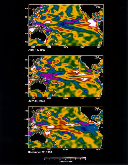
Sea Level
Published:
September 13, 2010
Sea Level
ENLARGE
Related
Jason-1 in full flight configuration
Jason-1 in full flight configuration
Headed for Orbit!
Headed for Orbit!
Ionospheric Total Electron Content
Ionospheric Total Electron Content
Jason-1 launch images
Jason-1 launch images
Jason-1 readies for launch in its bay at Vandenberg, AFB (10/31/01)
Jason-1 readies for launch in its bay at Vandenberg, AFB (10/31/01)
Poseidon-3 Altimeter
Poseidon-3 Altimeter
Jason-1 readies for launch in its bay at Vandenberg, AFB (10/31/01)
Jason-1 readies for launch in its bay at Vandenberg, AFB (10/31/01)
Jason-1 launch images
Jason-1 launch images
The SpaceX Falcon 9 with the Sentinel-6 Michael Freilich satellite is lifted to vertical at Space Launch Complex 4
Sentinel-6 on pad at SLC-4, VAFB
The Antonov cargo aircraft carrying the Sentinel-6 Michael Freilich satellite touches down on the runway at Vandenberg Air Force Base in California on Sept. 24, 2020.
Sentinel-6 Spacecraft Arrival/Offload
Jason-1 Line Drawing
Jason-1 Line Drawing
Jason-1: JMR instrument
Jason-1: JMR instrument
Jason-1 Altimeter
Jason-1 Altimeter
TOPEX/Poseidon Altimeter
TOPEX/Poseidon Altimeter
Jason-1 atop the Delta II Photo: Tom Shain
Jason-1 atop the Delta II Photo: Tom Shain
Jason-1 launch images
Jason-1 launch images
These photos were taken during the Payload Attach Fitting (PAF) mating operation with Jason-1. (11/14/01) Photos: Scott Michel
These photos were taken during the Payload Attach Fitting (PAF) mating operation with Jason-1. (11/14/01) Photos: Scott Michel
SpaceX Falcon 9 Rocket
SpaceX Falcon 9 Rocket
OSTM/Jason-2 Radiometer Antenna
OSTM/Jason-2 Radiometer Antenna
These photos were taken during the Dual Payload Attach Fitting (DPAF) mating operation with Jason-1. (11/13/01) Photos: Scott Michel
These photos were taken during the Dual Payload Attach Fitting (DPAF) mating operation with Jason-1. (11/13/01) Photos: Scott Michel
OSTM/Jason-2 Radiometer Antenna
OSTM/Jason-2 Radiometer Antenna
t - 12 minutes
t - 12 minutes
Water Vapor
Water Vapor
This illustration shows the Sentinel-6 Michael Freilich spacecraft in orbit above Earth with its deployable solar panels extended.
Sentinel-6 Michael Freilich Artist's Rendering
OSTM/Jason-2 Artist's Concept
OSTM/Jason-2 Artist's Concept