NASA
Jet Propulsion Laboratory California Institute of Technology
Skip Navigation
Ocean Surface Topography from Space
Stay Connected
menu close modal

Resources

Altimeter Mission Series

Altimeter Mission Series
Published: October 18, 2021

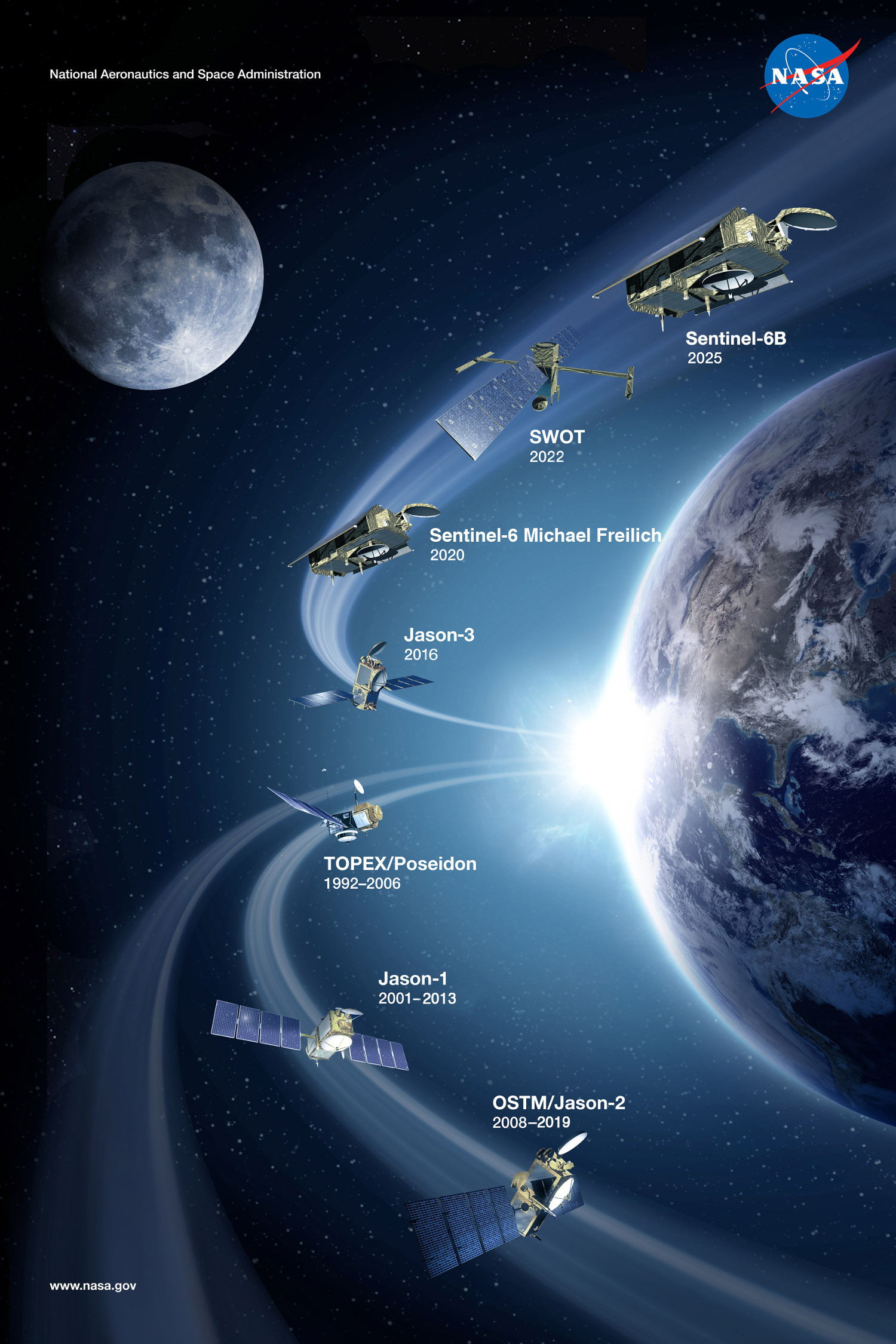
This poster shows past, present and future altimetry missions.

Download Options:

  • High Resolution (10.2 MB)
  • Medium Resolution JPEG (5.9 MB)

ENLARGE

Downloads

Altimeter Mission Series
1.7 MB
image/jpeg
Download

More Like This

  • Graphics
  • Spacecraft

Related

El Niño/La Niña
More
El Niño/La Niña
El Niño/La Niña
SpaceX Falcon 9 rocket with the Sentinel-6 Michael Freilich satellite is lifted to vertical at Space Launch Complex 4
More
Falcon 9 vertical on pad
Sentinel-6 on pad at SLC-4, VAFB
QuickTime VR of TOPEX/Poseidon
More
QuickTime VR of TOPEX/Poseidon
Jason-1: TRSR instrument
More
Jason-1: TRSR instrument
Jason-1: JMR instrument
More
Jason-1: JMR instrument
A key ocean observation satellite has been named after Earth scientist Michael Freilich
More
A key ocean observation satellite has been named after Earth scientist Michael Freilich
Ocean Satellite Renamed for Noted Scientist
OSTM/Jason-2 Artist's Concept
More
OSTM/Jason-2 Artist's Concept
OSTM/Jason-2 Spacecraft
More
OSTM/Jason-2 Spacecraft
Oceans' Role in Climate - Jason-1
More
Oceans' Role in Climate - Jason-1
Headed for Orbit!
More
Launch photo of the OSTM spacecraft.
Headed for Orbit!
Recorded live launch broadcast of Sentinel-6 Michael Freilich
More
Recorded live launch broadcast of Sentinel-6 Michael Freilich
Watch the Launch of the Ocean-Observing Sentinel-6 Michael Freilich Satellite
SpaceX Falcon 9 Rocket
More
SpaceX Falcon 9 Rocket
This artist's concept show Jason-3 over France.
More
This artist's concept show Jason-3 over France.
Jason-3 over France
Jason-1 Pin
More
Jason-1 Pin
Jason-1 Pin
For NASA JPL engineer Parag Vaze, studying Earth’s rising ocean has been a career three decades in the making.
More
For NASA JPL engineer Parag Vaze, studying Earth’s rising ocean has been a career three decades in the making.
NASA Engineer Observes Sea Level Rise from Space for 30 Years
These photos were taken during the Dual Payload Attach Fitting (DPAF) mating operation with Jason-1. (11/13/01) Photos: Scott Michel
More
These photos were taken during the Dual Payload Attach Fitting (DPAF) mating operation with Jason-1. (11/13/01) Photos: Scott Michel
Jason-3 3D Model
More
3d model of Jason-3 spacecraft
Jason-3 3D Model
This artist's concept show Jason-3 over the Amazon.
More
This artist's concept show Jason-3 over the Amazon.
Jason-3 over the Amazon
Jason-1 Lithograph
More
Jason-1 Lithograph
Jason-1 Lithograph
High Resolution Jason-1 launch images
More
High Resolution Jason-1 launch images
Jason-1 readies for launch in its bay at Vandenberg, AFB (10/31/01)
More
Jason-1 readies for launch in its bay at Vandenberg, AFB (10/31/01)
Jason-1 Measurement System
More
Jason-1 Measurement System
These photos were taken during the Dual Payload Attach Fitting (DPAF) mating operation with Jason-1. (11/13/01) Photos: Scott Michel
More
These photos were taken during the Dual Payload Attach Fitting (DPAF) mating operation with Jason-1. (11/13/01) Photos: Scott Michel
TOPEX/Poseidon Measurement System
More
TOPEX/Poseidon Measurement System
CNES Jason Logo
More
CNES Jason Logo
CNES Jason Logo
more resources

Get the Newsletter

Follow JPL

Home

Ocean Observation

    • Why Study the Ocean?
    • Understanding Climate
    • Ocean Surface Topography

Science

    • Goals & Objectives
    • Publications
    • Scientific Investigations
    • Science Team Meetings

Applications

    • Overview
    • Water Cycle
    • Operational
    • Coastal
    • Biological
    • Climate
    • Hazards

Data

    • Get Data
    • Along-Track Near Real-Time Data
    • El Niño/La Niña Watch & PDO
    • Vital Signs

Missions

    • Overview
    • Technology
    • Jason-CS (Sentinel 6)
    • Jason-3
    • OSTM/Jason-2
    • Jason-1
    • TOPEX/Poseidon

News

Resources

  • NASA
  • |
  • CALTECH
  • |
  • Privacy
  • |
  • Image Policy
  • |
  • Feedback
  • |
  • Accessibility

Site Manager: Kalina Velev