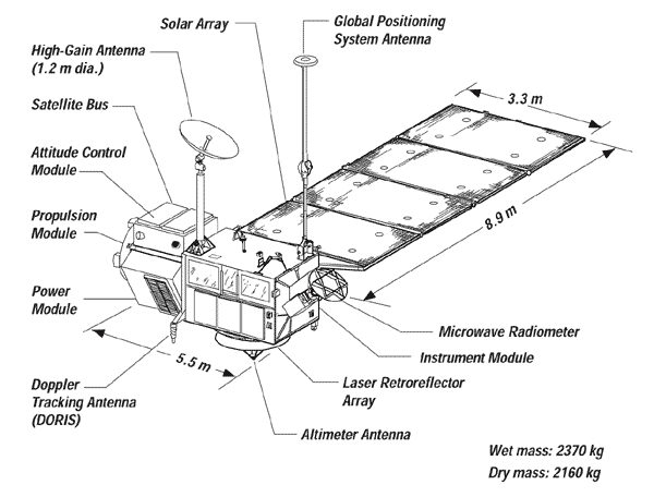
NASA
Jet Propulsion Laboratory California Institute of Technology
Skip Navigation
Ocean Surface Topography from Space
Stay Connected
menu close modal

Resources

TOPEX/Poseidon Line Drawing

TOPEX/Poseidon Line Drawing
Published: September 13, 2010

TOPEX/Poseidon Line Drawing

ENLARGE

Downloads

TOPEX/Poseidon Line Drawing
21.1 KB
image/gif
Download

More Like This

  • Images
  • Spacecraft

Related

These photos were taken during the Payload Attach Fitting (PAF) mating operation with Jason-1. (11/14/01) Photos: Scott Michel
More
These photos were taken during the Payload Attach Fitting (PAF) mating operation with Jason-1. (11/14/01) Photos: Scott Michel
Jason-3 Launch
More
Jason-3 Launch
Jason-3 Launch
TOPEX/Poseidon Ground Tracks
More
TOPEX/Poseidon Ground Tracks
Jason-1 Spacecraft Animation
More
Jason-1 Spacecraft Animation
t - 12 minutes
More
t - 12 minutes
t - 12 minutes
Jason-3 on the Launch Pad
More
Jason-3 on the Launch Pad
OSTM/Jason-2 Spacecraft
More
OSTM/Jason-2 Spacecraft
Recorded live launch broadcast of Sentinel-6 Michael Freilich
More
Recorded live launch broadcast of Sentinel-6 Michael Freilich
Watch the Launch of the Ocean-Observing Sentinel-6 Michael Freilich Satellite
SpaceX Falcon 9 rocket, topped with the Sentinel-6 Michael Freilich satellite secured inside its payload fairing, is rolled to Space Launch Complex 4
More
Falcon 9 rolled to pad
Sentinel-6 Rollout at SLC-4, VAFB
Jason-1 launch images
More
Jason-1 launch images
Wind Speed
More
Wind Speed
Wind Speed
For NASA JPL engineer Parag Vaze, studying Earth’s rising ocean has been a career three decades in the making.
More
For NASA JPL engineer Parag Vaze, studying Earth’s rising ocean has been a career three decades in the making.
NASA Engineer Observes Sea Level Rise from Space for 30 Years
Launch preparations are progressing! (11/21/01) Photos: Stacy Mitchell of John Hopkins APL/TIMED project
More
Launch preparations are progressing! (11/21/01) Photos: Stacy Mitchell of John Hopkins APL/TIMED project
High Resolution Jason-1 launch images
More
High Resolution Jason-1 launch images
Wave Height
More
Wave Height
Wave Height
Jason-1 launch images
More
Jason-1 launch images
OSTM/Jason-2 GPSP
More
OSTM/Jason-2 GPSP
OSTM/Jason-2 GPSP
The joint U.S.-European Sentinel-6 Michael Freilich is the next in a line of Earth-observing satellites that will collect the most accurate data yet on sea level and how it changes over time. With ...
More
A video overview of the Sentinel-6 mission.
New U.S.-European Satellite Tracking Sea Level Rise
Jason-1 readies for launch in its bay at Vandenberg, AFB (10/31/01)
More
Jason-1 readies for launch in its bay at Vandenberg, AFB (10/31/01)
These photos were taken during the Payload Attach Fitting (PAF) mating operation with Jason-1. (11/14/01) Photos: Scott Michel
More
These photos were taken during the Payload Attach Fitting (PAF) mating operation with Jason-1. (11/14/01) Photos: Scott Michel
Variability of Ocean Dynamic Topography
More
Variability of Ocean Dynamic Topography
Radiometer Rework - April 2007
More
Radiometer Rework - April 2007
TOPEX/Poseidon DORIS
More
TOPEX/Poseidon DORIS
Jason-3 3D Model
More
3d model of Jason-3 spacecraft
Jason-3 3D Model
TOPEX/Poseidon Radiometer
More
TOPEX/Poseidon Radiometer
more resources

Get the Newsletter

Follow JPL

Home

Ocean Observation

    • Why Study the Ocean?
    • Understanding Climate
    • Ocean Surface Topography

Science

    • Goals & Objectives
    • Publications
    • Scientific Investigations
    • Science Team Meetings

Applications

    • Overview
    • Water Cycle
    • Operational
    • Coastal
    • Biological
    • Climate
    • Hazards

Data

    • Get Data
    • Along-Track Near Real-Time Data
    • El Niño/La Niña Watch & PDO
    • Vital Signs

Missions

    • Overview
    • Technology
    • Jason-CS (Sentinel 6)
    • Jason-3
    • OSTM/Jason-2
    • Jason-1
    • TOPEX/Poseidon

News

Resources

  • NASA
  • |
  • CALTECH
  • |
  • Privacy
  • |
  • Image Policy
  • |
  • Feedback
  • |
  • Accessibility

Site Manager: Margaret Srinivassan