NASA
Jet Propulsion Laboratory
California Institute of Technology
Skip Navigation
Ocean Surface Topography from Space
Stay Connected
menu
close modal
Resources
Jason-1 launch images
Published:
September 13, 2010
Jason-1 launch images
ENLARGE
Related
These photos were taken during the Payload Attach Fitting (PAF) mating operation with Jason-1. (11/14/01) Photos: Scott Michel
These photos were taken during the Payload Attach Fitting (PAF) mating operation with Jason-1. (11/14/01) Photos: Scott Michel
TOPEX/Poseidon Altimeter
TOPEX/Poseidon Altimeter
Watch the Jason-3 Mission Briefing from Friday, Jan 15, 2016 - panelists gave an overview of the Jason-3 mission.
Getting To Know Jason-3
Jason-3 3D Model
Jason-3 3D Model
OSTM/Jason-2 GPSP
OSTM/Jason-2 GPSP
Early morning at the launch pad
Early morning at the launch pad
Ionospheric Total Electron Content
Ionospheric Total Electron Content
These photos were taken during the Dual Payload Attach Fitting (DPAF) mating operation with Jason-1. (11/13/01) Photos: Scott Michel
These photos were taken during the Dual Payload Attach Fitting (DPAF) mating operation with Jason-1. (11/13/01) Photos: Scott Michel
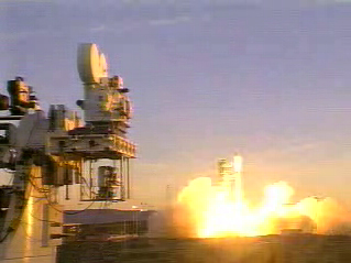
High Resolution Jason-1 launch images
High Resolution Jason-1 launch images
OSTM/Jason-2 Spacecraft
OSTM/Jason-2 Spacecraft
TOPEX/Poseidon Mission to Planet Earth
TOPEX/Poseidon Mission to Planet Earth
OSTM/Jason-2 GPSP
OSTM/Jason-2 GPSP
The ocean-observing Sentinel-6 Michael Freilich satellite launched from Vandenberg Air Force Base in California aboard a SpaceX Falcon 9 rocket on Nov. 21, 2020 at 12:17 p.m. EST
NASA and SpaceX Launch U.S.-European Mission to Monitor World's Ocean (Recap)
The SpaceX Falcon 9 rocket carrying the Sentinel-6 Michael Freilich spacecraft lifts off from Space Launch Complex 4 at Vandenberg Air Force Base in California, Nov. 21, 2020, at 9:17 a.m. PST
Sentinel-6 Launch
Jason-1 Artists Concept
Jason-1 Artists Concept
These photos were taken during the Dual Payload Attach Fitting (DPAF) mating operation with Jason-1. (11/13/01) Photos: Scott Michel
These photos were taken during the Dual Payload Attach Fitting (DPAF) mating operation with Jason-1. (11/13/01) Photos: Scott Michel
Jason-1 atop the Delta II Photo: Tom Shain
Jason-1 atop the Delta II Photo: Tom Shain
Radiometer Rework - April 2007
Radiometer Rework - April 2007
This artist's concept show Jason-3 over the Amazon.
Jason-3 over the Amazon
Recorded live broadcast of Sentinel-6B, launched at 9:21 p.m. PST, Sunday, Nov. 16 (12:21 a.m. EST, Monday, Nov. 17) aboard a SpaceX Falcon 9 rocket from Vandenberg Space Force Base in California.
Relive the Launch: Sentinel-6B
Launch preparations are progressing! (11/21/01) Photos: Stacy Mitchell of John Hopkins APL/TIMED project
Launch preparations are progressing! (11/21/01) Photos: Stacy Mitchell of John Hopkins APL/TIMED project
These photos were taken during the Dual Payload Attach Fitting (DPAF) mating operation with Jason-1. (11/13/01) Photos: Scott Michel
These photos were taken during the Dual Payload Attach Fitting (DPAF) mating operation with Jason-1. (11/13/01) Photos: Scott Michel
Sentinel-6 Michael Freilich Launch footage
Sentinel-6 Michael Freilich Launch Footage
Launch preparations are progressing! (11/21/01) Photos: Stacy Mitchell of John Hopkins APL/TIMED project
Launch preparations are progressing! (11/21/01) Photos: Stacy Mitchell of John Hopkins APL/TIMED project
Jason-1 readies for launch in its bay at Vandenberg, AFB (10/31/01)
Jason-1 readies for launch in its bay at Vandenberg, AFB (10/31/01)