NASA
Jet Propulsion Laboratory
California Institute of Technology
Skip Navigation
Ocean Surface Topography from Space
Stay Connected
menu
close modal
Resources
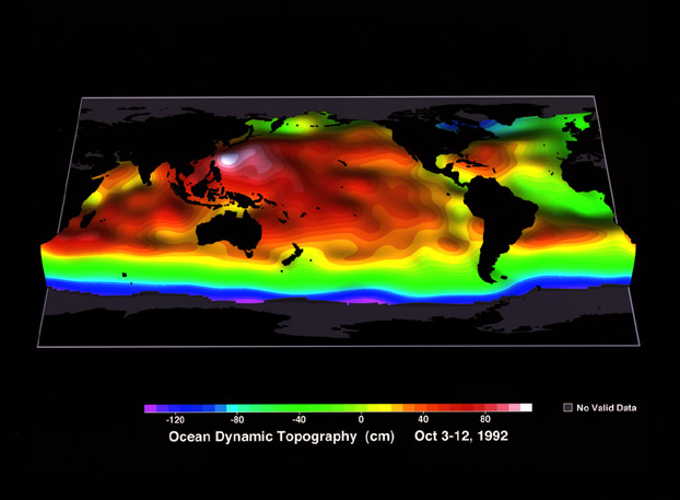
Ocean Dynamic Topography
Published:
September 13, 2010
Ocean Dynamic Topography
ENLARGE
Related
Radiometer Install - Jan. 2007
Radiometer Install - Jan. 2007
The SpaceX Falcon 9 with the Sentinel-6 Michael Freilich satellite is lifted to vertical at Space Launch Complex 4
Sentinel-6 on pad at SLC-4, VAFB
OSTM/Jason-2 Spacecraft
OSTM/Jason-2 Spacecraft
High Resolution Jason-1 launch images
High Resolution Jason-1 launch images
Jason-1: First Image
Jason-1: First Image
Sea Surface Height
Sea Surface Height
Jason-3 on the Launch Pad
Jason-3 on the Launch Pad
TOPEX/Poseidon launch
TOPEX/Poseidon launch
This artist's concept show Jason-3 over France.
Jason-3 over France
OSTM/Jason-2 Artist's Concept
OSTM/Jason-2 Artist's Concept
t - 10 minutes
t - 10 minutes
TOPEX/Poseidon GPS
TOPEX/Poseidon GPS
TOPEX/Poseidon over Earth
TOPEX/Poseidon over Earth
Whale Census and Habitat
Whale Census and Habitat
Sea Level
Sea Level
TOPEX/Poseidon DORIS
TOPEX/Poseidon DORIS
The SpaceX Falcon 9 rocket carrying the Sentinel-6 Michael Freilich spacecraft lifts off from Space Launch Complex 4 at Vandenberg Air Force Base in California, Nov. 21, 2020, at 9:17 a.m. PST
Sentinel-6 Launch
Jason-3 Ready for Launch
Jason-3 Ready for Launch
Jason-1 readies for launch in its bay at Vandenberg, AFB (10/31/01)
Jason-1 readies for launch in its bay at Vandenberg, AFB (10/31/01)
Jason-3
Jason-3
Jason-1 launch images
Jason-1 launch images
Radiometer Rework - April 2007
Radiometer Rework - April 2007
TOPEX/Poseidon Radiometer
TOPEX/Poseidon Radiometer
Jason-1 Altimeter
Jason-1 Altimeter
Jason-1 DORIS
Jason-1 DORIS