NASA
Jet Propulsion Laboratory
California Institute of Technology
Skip Navigation
Ocean Surface Topography from Space
Stay Connected
menu
close modal
Resources
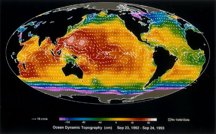
Ocean Dynamic Topography
Published:
September 13, 2010
Ocean Dynamic Topography
ENLARGE
Related
TOPEX/Poseidon DORIS
TOPEX/Poseidon DORIS
Bringing Satellite Data Down to Earth
Bringing Satellite Data Down to Earth
Jason-3 Ready for Launch
Jason-3 Ready for Launch
TOPEX/Poseidon over Earth
TOPEX/Poseidon over Earth
Early morning at the launch pad
Early morning at the launch pad
OSTM/Jason-2 DORIS
OSTM/Jason-2 DORIS
Jason-1 atop the Delta II Photo: Tom Shain
Jason-1 atop the Delta II Photo: Tom Shain
OSTM/Jason-2 GPSP
OSTM/Jason-2 GPSP
Jason-1 Altimeter
Jason-1 Altimeter
Jason-1 launch images
Jason-1 launch images
The Falcon 9 protective payload fairing containing the Sentinel-6 Michael Freilich satellite
Payload fairing containing the Sentinel-6 Michael Freilich satellite
Jason-3
Jason-3
High Resolution Jason-1 launch images
High Resolution Jason-1 launch images
Launched on January 17, 2016, Jason-3 is a partnership that includes NOAA, NASA, CNES, and EUMETSAT. The map shown here was generated using sea surface height measurements from the first 10 days (...
Jason-3 Begins Mapping the Ocean
Jason-1: LRA instrument
Jason-1: LRA instrument
Altimeter Applications - JPL Open House '99
Altimeter Applications - JPL Open House '99
The Antonov cargo aircraft carrying the Sentinel-6 Michael Freilich satellite touches down on the runway at Vandenberg Air Force Base in California on Sept. 24, 2020.
Sentinel-6 Spacecraft Arrival/Offload
SpaceX Falcon 9 rocket, topped with the Sentinel-6 Michael Freilich satellite secured inside its payload fairing, is rolled to Space Launch Complex 4
Sentinel-6 Rollout at SLC-4, VAFB
This illustration shows the Sentinel-6 Michael Freilich spacecraft in orbit above Earth with its deployable solar panels extended.
Sentinel-6 Michael Freilich Artist's Rendering
The Antonov cargo aircraft carrying the Sentinel-6 Michael Freilich satellite touches down on the runway at Vandenberg Air Force Base in California on Sept. 24, 2020.
Sentinel-6 Spacecraft Arrival/Offload
OSTM/Jason-2 GPSP
OSTM/Jason-2 GPSP
The SpaceX Falcon 9 rocket carrying the Sentinel-6 Michael Freilich spacecraft lifts off from Space Launch Complex 4 at Vandenberg Air Force Base in California, Nov. 21, 2020, at 9:17 a.m. PST
Sentinel-6 Launch
TOPEX/Poseidon Collecting Data
TOPEX/Poseidon Collecting Data
Radiometer Installation Team - April 2007
Radiometer Installation Team - April 2007
Jason-3 Lifts Off!
Jason-3 Lifts Off!