NASA
Jet Propulsion Laboratory
California Institute of Technology
Skip Navigation
Ocean Surface Topography from Space
Stay Connected
menu
close modal
Resources
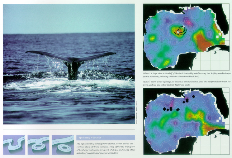
Whale Census and Habitat
Published:
September 13, 2010
Whale Census and Habitat
ENLARGE
Related
Jason-1 readies for launch in its bay at Vandenberg, AFB (10/31/01)
Jason-1 readies for launch in its bay at Vandenberg, AFB (10/31/01)
Jason-3 Satellite Prepared For Launch
Jason-3 Satellite Prepared For Launch
Jason-1 Launch Configuration
Jason-1 Launch Configuration
The SpaceX Falcon 9 with the Sentinel-6 Michael Freilich satellite is lifted to vertical at Space Launch Complex 4
Sentinel-6 on pad at SLC-4, VAFB
Jason-1: First Image
Jason-1: First Image
After living in coastal Virginia and seeing the effects of climate change firsthand, Ben Hamlington is now researching sea level rise at NASA JPL.
NASA Scientist Studies Sea Level Rise from Space
This is an artist's concept of the Sentinel-6 Michael Freilich spacecraft.
Artist's concept of Sentinel-6 Michael Freilich
The SpaceX Falcon 9 rocket, topped with the Sentinel-6 Michael Freilich satellite secured inside its payload fairing, is rolled to Space Launch Complex 4
Sentinel-6 Rollout at SLC-4, VAFB
This artist's concept shows Jason-3 over the California coast.
Jason-3 over California
Launch preparations are progressing! (11/21/01) Photos: Stacy Mitchell of John Hopkins APL/TIMED project
Launch preparations are progressing! (11/21/01) Photos: Stacy Mitchell of John Hopkins APL/TIMED project
Jason-1 Altimeter
Jason-1 Altimeter
Jason-1 launch images
Jason-1 launch images
Earth’s rising seas are some of the most visible signs of our warming planet. Over the last 23 years, NASA satellite missions have observed a steady rise in global sea levels as polar ice sheets me...
Earth's Rising Seas
For NASA engineer Shannon Statham, building spacecraft is all about being creative.
From Tuning Antennas to Making Dresses, Engineer Puts the A in STEAM
Launch preparations are progressing! (11/21/01) Photos: Stacy Mitchell of John Hopkins APL/TIMED project
Launch preparations are progressing! (11/21/01) Photos: Stacy Mitchell of John Hopkins APL/TIMED project
Jason-1 readies for launch in its bay at Vandenberg, AFB (10/31/01)
Jason-1 readies for launch in its bay at Vandenberg, AFB (10/31/01)
Variability of Ocean Dynamic Topography
Variability of Ocean Dynamic Topography
Jason-1 Artists Concept
Jason-1 Artists Concept
OSTM/Jason-2 Radiometer Antenna
OSTM/Jason-2 Radiometer Antenna
The SpaceX Falcon 9 rocket carrying the Sentinel-6 Michael Freilich spacecraft lifts off from Space Launch Complex 4 at Vandenberg Air Force Base in California, Nov. 21, 2020, at 9:17 a.m. PST
Sentinel-6 Launch
Jason-1 in full flight configuration
Jason-1 in full flight configuration
The Antonov cargo aircraft carrying the Sentinel-6 Michael Freilich satellite touches down on the runway at Vandenberg Air Force Base in California on Sept. 24, 2020.
Sentinel-6 Spacecraft Arrival/Offload
The Falcon 9 protective payload fairing containing the Sentinel-6 Michael Freilich satellite
Payload fairing containing the Sentinel-6 Michael Freilich satellite
In this illustration, the Sentinel-6 Michael Freilich spacecraft - the world's latest sea-level satellite - orbits Earth with its deployable solar panels extended.
Sentinel-6 Michael Freilich Satellite Orbits Earth (Illustration)
These photos were taken during the Dual Payload Attach Fitting (DPAF) mating operation with Jason-1. (11/13/01) Photos: Scott Michel
These photos were taken during the Dual Payload Attach Fitting (DPAF) mating operation with Jason-1. (11/13/01) Photos: Scott Michel