NASA
Jet Propulsion Laboratory
California Institute of Technology
Skip Navigation
Ocean Surface Topography from Space
Stay Connected
menu
close modal
Resources
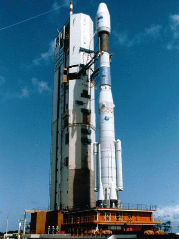
Ariane 42P launch vehicle
Published:
September 13, 2010
Ariane 42P launch vehicle
ENLARGE
Related
A SpaceX Falcon 9 rocket lifts off from Space Launch Complex 4 at Vandenberg Air Force Base carrying the Jason-3 spacecraft. Liftoff was at 10:42 a.m. PST (1:42 p.m. EST).
Liftoff of Jason-3
This artist's concept shows Jason-3 over the California coast.
Jason-3 over California
The Sentinel-6 Michael Freilich satellite sits in front of a testing chamber where mission team members tested whether the spacecraft could endure the loud sounds it will encounter during launch.
Testing of Sentintel-6 Michael Freilich satellite
Jason-1 TRSR
Jason-1 TRSR
TOPEX/Poseidon DORIS
TOPEX/Poseidon DORIS
Poseidon-3 Altimeter
Poseidon-3 Altimeter
Jason-3 on the Launch Pad
Jason-3 on the Launch Pad
Sentinel-6 Michael Freilich Launch footage
Sentinel-6 Michael Freilich Launch Footage
Applications of Spaceborne Altimetry
Applications of Spaceborne Altimetry
Jason-3 Lifts Off!
Jason-3 Lifts Off!
Launch preparations are progressing! (11/21/01) Photos: Stacy Mitchell of John Hopkins APL/TIMED project
Launch preparations are progressing! (11/21/01) Photos: Stacy Mitchell of John Hopkins APL/TIMED project
TOPEX/Poseidon over Earth
TOPEX/Poseidon over Earth
These photos were taken during the Dual Payload Attach Fitting (DPAF) mating operation with Jason-1. (11/13/01) Photos: Scott Michel
These photos were taken during the Dual Payload Attach Fitting (DPAF) mating operation with Jason-1. (11/13/01) Photos: Scott Michel
Oceans' Role in Climate - Jason-1
Oceans' Role in Climate - Jason-1
Jason-1 readies for launch in its bay at Vandenberg, AFB (10/31/01)
Jason-1 readies for launch in its bay at Vandenberg, AFB (10/31/01)
The Antonov cargo aircraft carrying the Sentinel-6 Michael Freilich satellite touches down on the runway at Vandenberg Air Force Base in California on Sept. 24, 2020.
Sentinel-6 Spacecraft Arrival/Offload
TOPEX/Poseidon Mission to Planet Earth
TOPEX/Poseidon Mission to Planet Earth
Experts from NASA, ESA, EUMETSAT, and NOAA discuss the upcoming launch of Sentinel-6 Michael Freilich in a recorded live broadcast
News Update on Launch of the Sea Level-Monitoring Satellite, Sentinel-6 Michael Freilich
Jason-3
Jason-3
Launch preparations are progressing! (11/21/01) Photos: Stacy Mitchell of John Hopkins APL/TIMED project
Launch preparations are progressing! (11/21/01) Photos: Stacy Mitchell of John Hopkins APL/TIMED project
OSTM/Jason-2 GPSP
OSTM/Jason-2 GPSP
Radiometer Rework - April 2007
Radiometer Rework - April 2007
Jason-1 LRA
Jason-1 LRA
Jason-3 Animation
Jason-3 Animation
In this illustration, the Sentinel-6 Michael Freilich spacecraft - the world's latest sea-level satellite - orbits Earth with its deployable solar panels extended.
Sentinel-6 Michael Freilich Satellite Orbits Earth (Illustration)