NASA
Jet Propulsion Laboratory
California Institute of Technology
Skip Navigation
Ocean Surface Topography from Space
Stay Connected
menu
close modal
Resources
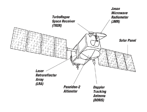
Jason-1 Line Drawing
Published:
September 13, 2010
Jason-1 Line Drawing
ENLARGE
Related
Sea Surface Height
Sea Surface Height
Launch preparations are progressing! (11/21/01) Photos: Stacy Mitchell of John Hopkins APL/TIMED project
Launch preparations are progressing! (11/21/01) Photos: Stacy Mitchell of John Hopkins APL/TIMED project
The Antonov cargo aircraft carrying the Sentinel-6 Michael Freilich satellite touches down on the runway at Vandenberg Air Force Base in California on Sept. 24, 2020.
Sentinel-6 Spacecraft Arrival/Offload
Launch preparations are progressing! (11/21/01) Photos: Stacy Mitchell of John Hopkins APL/TIMED project
Launch preparations are progressing! (11/21/01) Photos: Stacy Mitchell of John Hopkins APL/TIMED project
These photos were taken during the Payload Attach Fitting (PAF) mating operation with Jason-1. (11/14/01) Photos: Scott Michel
These photos were taken during the Payload Attach Fitting (PAF) mating operation with Jason-1. (11/14/01) Photos: Scott Michel
Whale Census and Habitat
Whale Census and Habitat
High Resolution Jason-1 launch images
High Resolution Jason-1 launch images
OSTM/Jason-2 LRA
OSTM/Jason-2 LRA
Spacecraft processing
Sentinel-6 Michael Freilich spacecraft processing
Jason-1 in full flight configuration
Jason-1 in full flight configuration
These photos were taken during the Payload Attach Fitting (PAF) mating operation with Jason-1. (11/14/01) Photos: Scott Michel
These photos were taken during the Payload Attach Fitting (PAF) mating operation with Jason-1. (11/14/01) Photos: Scott Michel
Our planet is changing. Our ocean is rising. And it affects us all. That’s why a new international satellite will continue the decades-long watch over our global ocean and help us better understand...
Behind the Spacecraft – Sentinel-6 Michael Freilich
These photos were taken during the Dual Payload Attach Fitting (DPAF) mating operation with Jason-1. (11/13/01) Photos: Scott Michel
These photos were taken during the Dual Payload Attach Fitting (DPAF) mating operation with Jason-1. (11/13/01) Photos: Scott Michel
Applications of Spaceborne Altimetry
Applications of Spaceborne Altimetry
Variability of Ocean Dynamic Topography
Variability of Ocean Dynamic Topography
NASA and its U.S. and international partners have teamed up to launch a new Earth-observing satellite called Sentinel-6B that will measure sea surface height of most of the planet’s ocean. These ob...
Sentinel-6B: Extending the Legacy
Jason-3
Jason-3
The joint U.S.-European Sentinel-6 Michael Freilich is the next in a line of Earth-observing satellites that will collect the most accurate data yet on sea level and how it changes over time. With ...
New U.S.-European Satellite Tracking Sea Level Rise
Sentinel-6 Michael Freilich will join a long-standing family of Earth observing satellites from NASA and European partners.
Sentinel-6 Michael Freilich Satellite Family Tree
High Resolution Jason-1 launch images
High Resolution Jason-1 launch images
Early morning at the launch pad
Early morning at the launch pad
t - 12 minutes
t - 12 minutes
OSTM/Jason-2 Radiometer Antenna
OSTM/Jason-2 Radiometer Antenna
This artist's concept show Jason-3 over the Amazon.
Jason-3 over the Amazon
Mike Davis in front of the faring
Mike Davis in front of the faring