NASA
Jet Propulsion Laboratory
California Institute of Technology
Skip Navigation
Ocean Surface Topography from Space
Stay Connected
menu
close modal
Resources
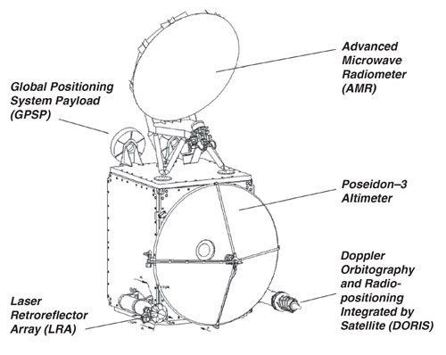
OSTM/Jason-2 Line Drawing
Published:
September 13, 2010
OSTM/Jason-2 Line Drawing
ENLARGE
Related
OSTM/Jason-2 Artist's Concept
OSTM/Jason-2 Artist's Concept
Mission team members perform acoustic tests of the Sentinel-6 Michael Freilich satellite in a chamber outfitted with giant speakers that blast the spacecraft with sound. This is to ensure that the ...
Testing of Sentinel-6 Michael Freilich satellite
OSTM/Jason-2 DORIS
OSTM/Jason-2 DORIS
In this illustration, the Sentinel-6 Michael Freilich spacecraft - the world's latest sea-level satellite - orbits Earth with its deployable solar panels extended.
Sentinel-6 Michael Freilich Satellite Orbits Earth (Illustration)
Bringing Satellite Data Down to Earth
Bringing Satellite Data Down to Earth
Ocean Dynamic Topography
Ocean Dynamic Topography
These photos were taken during the Dual Payload Attach Fitting (DPAF) mating operation with Jason-1. (11/13/01) Photos: Scott Michel
These photos were taken during the Dual Payload Attach Fitting (DPAF) mating operation with Jason-1. (11/13/01) Photos: Scott Michel
Jason-3 Ready for Launch
Jason-3 Ready for Launch
Jason-1 launch images
Jason-1 launch images
Radiometer Rework - April 2007
Radiometer Rework - April 2007
Whale Census and Habitat
Whale Census and Habitat
Jason-3 Lifts Off!
Jason-3 Lifts Off!
The Antonov cargo aircraft carrying the Sentinel-6 Michael Freilich satellite touches down on the runway at Vandenberg Air Force Base in California on Sept. 24, 2020.
Sentinel-6 Spacecraft Arrival/Offload
Sentinel-6 Michael Freilich will join a long-standing family of Earth observing satellites from NASA and European partners.
Sentinel-6 Michael Freilich Satellite Family Tree
Recorded live launch broadcast of Sentinel-6 Michael Freilich
Watch the Launch of the Ocean-Observing Sentinel-6 Michael Freilich Satellite
Watch the Jason-3 Mission Briefing from Friday, Jan 15, 2016 - panelists gave an overview of the Jason-3 mission.
Getting To Know Jason-3
Jason-1 Launch Configuration
Jason-1 Launch Configuration
Jason-1 LRA
Jason-1 LRA
The Falcon 9 protective payload fairing containing the Sentinel-6 Michael Freilich satellite
Payload fairing containing the Sentinel-6 Michael Freilich satellite
QuickTime VR of TOPEX/Poseidon
QuickTime VR of TOPEX/Poseidon
Launch preparations are progressing! (11/21/01) Photos: Stacy Mitchell of John Hopkins APL/TIMED project
Launch preparations are progressing! (11/21/01) Photos: Stacy Mitchell of John Hopkins APL/TIMED project
OSTM/Jason-2 Radiometer Antenna
OSTM/Jason-2 Radiometer Antenna
This artist's concept shows Jason-3 over the California coast.
Jason-3 over California
Sea Surface Height
Sea Surface Height
Headed for Orbit!
Headed for Orbit!