NASA
Jet Propulsion Laboratory
California Institute of Technology
Skip Navigation
Ocean Surface Topography from Space
Stay Connected
menu
close modal
Resources
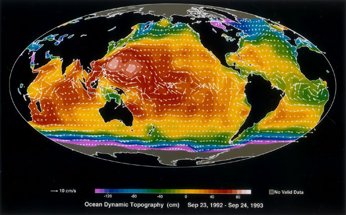
Ocean Dynamic Topography
Published:
September 13, 2010
Ocean Dynamic Topography
ENLARGE
Related
Launch preparations are progressing! (11/21/01) Photos: Stacy Mitchell of John Hopkins APL/TIMED project
Launch preparations are progressing! (11/21/01) Photos: Stacy Mitchell of John Hopkins APL/TIMED project
This artist's concept show Jason-3 over France.
Jason-3 over France
Whale Census and Habitat
Whale Census and Habitat
Sea Level
Sea Level
The SpaceX Falcon 9 rocket carrying the Sentinel-6 Michael Freilich spacecraft lifts off from Space Launch Complex 4 at Vandenberg Air Force Base in California, Nov. 21, 2020, at 9:17 a.m. PST
Sentinel-6 Launch
Jason-1: First Image
Jason-1: First Image
The SpaceX Falcon 9 with the Sentinel-6 Michael Freilich satellite is lifted to vertical at Space Launch Complex 4
Sentinel-6 on pad at SLC-4, VAFB
High Resolution Jason-1 launch images
High Resolution Jason-1 launch images
Wind Speed
Wind Speed
This artist's concept shows Jason-3 over the California coast.
Jason-3 over California
Headed for Orbit!
Headed for Orbit!
OSTM/Jason-2 GPSP
OSTM/Jason-2 GPSP
TOPEX/Poseidon Line Drawing
TOPEX/Poseidon Line Drawing
Launch preparations are progressing! (11/21/01) Photos: Stacy Mitchell of John Hopkins APL/TIMED project
Launch preparations are progressing! (11/21/01) Photos: Stacy Mitchell of John Hopkins APL/TIMED project
Jason-3
Jason-3
These photos were taken during the Payload Attach Fitting (PAF) mating operation with Jason-1. (11/14/01) Photos: Scott Michel
These photos were taken during the Payload Attach Fitting (PAF) mating operation with Jason-1. (11/14/01) Photos: Scott Michel
El Niño is characterized by unusually warm ocean temperatures in the eastern equatorial Pacific. The warmer water associated with El Niño displaces colder water in the upper layer of the ocean caus...
Sea Surface Height Anomaly, 2014-2016
Jason-1 Line Drawing
Jason-1 Line Drawing
TOPEX/Poseidon Artist's Concept
TOPEX/Poseidon Artist's Concept
On the left is Sea Surface Height Anomalies (SSHA) relative to the sea level mean (1993-2018). On the right is Global Mean Sea Level (GMSL) with the sea level trend as the straight line. The data a...
Sea Surface Height Anomalies and Global Mean Sea Level
OSTM/Jason-2 Artist's Concept
OSTM/Jason-2 Artist's Concept
Early morning at the launch pad
Early morning at the launch pad
Jason-1 Artists Concept
Jason-1 Artists Concept
Jason-1 Altimeter
Jason-1 Altimeter
The Falcon 9 protective payload fairing containing the Sentinel-6 Michael Freilich satellite
Payload fairing containing the Sentinel-6 Michael Freilich satellite