NASA
Jet Propulsion Laboratory
California Institute of Technology
Skip Navigation
Ocean Surface Topography from Space
Stay Connected
menu
close modal
Resources
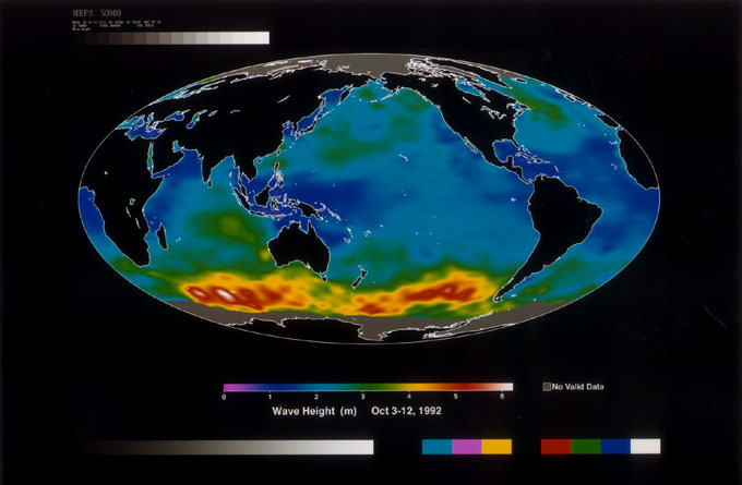
Wave Height
Published:
September 13, 2010
Wave Height
ENLARGE
Related
Applications of Spaceborne Altimetry
Applications of Spaceborne Altimetry
Jason-3
Jason-3
TOPEX/Poseidon Altimeter
TOPEX/Poseidon Altimeter
The SpaceX Falcon 9 rocket carrying the Sentinel-6 Michael Freilich spacecraft lifts off from Space Launch Complex 4 at Vandenberg Air Force Base in California, Nov. 21, 2020, at 9:17 a.m. PST
Sentinel-6 Launch
The SpaceX Falcon 9 rocket carrying the Sentinel-6 Michael Freilich spacecraft lifts off from Space Launch Complex 4 at Vandenberg Air Force Base in California, Nov. 21, 2020, at 9:17 a.m. PST
Sentinel-6 Launch
OSTM/Jason-2 Radiometer Antenna
OSTM/Jason-2 Radiometer Antenna
TOPEX/Poseidon LRA
TOPEX/Poseidon LRA
Headed for Orbit!
Headed for Orbit!
Early morning at the launch pad
Early morning at the launch pad
Jason-1 readies for launch in its bay at Vandenberg, AFB (10/31/01)
Jason-1 readies for launch in its bay at Vandenberg, AFB (10/31/01)
The SpaceX Falcon 9 rocket, topped with the Sentinel-6 Michael Freilich satellite secured inside its payload fairing, is rolled to Space Launch Complex 4
Sentinel-6 Rollout at SLC-4, VAFB
Altimeter Applications - JPL Open House '99
Altimeter Applications - JPL Open House '99
TOPEX/Poseidon Artist's Concept
TOPEX/Poseidon Artist's Concept
Mission team members perform acoustic tests of the Sentinel-6 Michael Freilich satellite in a chamber outfitted with giant speakers that blast the spacecraft with sound. This is to ensure that the ...
Testing of Sentinel-6 Michael Freilich satellite
Jason-1: First Image
Jason-1: First Image
High Resolution Jason-1 launch images
High Resolution Jason-1 launch images
Launch preparations are progressing! (11/21/01) Photos: Stacy Mitchell of John Hopkins APL/TIMED project
Launch preparations are progressing! (11/21/01) Photos: Stacy Mitchell of John Hopkins APL/TIMED project
Radiometer Rework - April 2007
Radiometer Rework - April 2007
Our Rising Seas infographic (version 2020)
Our Rising Seas
Jason-1 atop the Delta II Photo: Tom Shain
Jason-1 atop the Delta II Photo: Tom Shain
On the left is Sea Surface Height Anomalies (SSHA) relative to the sea level mean (1993-2018). On the right is Global Mean Sea Level (GMSL) with the sea level trend as the straight line. The data a...
Sea Surface Height Anomalies and Global Mean Sea Level
Jason-1 launch images
Jason-1 launch images
The Antonov cargo aircraft carrying the Sentinel-6 Michael Freilich satellite touches down on the runway at Vandenberg Air Force Base in California on Sept. 24, 2020.
Sentinel-6 Spacecraft Arrival/Offload
These photos were taken during the Payload Attach Fitting (PAF) mating operation with Jason-1. (11/14/01) Photos: Scott Michel
These photos were taken during the Payload Attach Fitting (PAF) mating operation with Jason-1. (11/14/01) Photos: Scott Michel
Jason-1: LRA instrument
Jason-1: LRA instrument