NASA
Jet Propulsion Laboratory
California Institute of Technology
Skip Navigation
Ocean Surface Topography from Space
Stay Connected
menu
close modal
Resources
t - 12 minutes
Published:
September 13, 2010
t - 12 minutes
ENLARGE
Related
Launch preparations are progressing! (11/21/01) Photos: Stacy Mitchell of John Hopkins APL/TIMED project
Launch preparations are progressing! (11/21/01) Photos: Stacy Mitchell of John Hopkins APL/TIMED project
Radiometer Installation Team - April 2007
Radiometer Installation Team - April 2007
Jason-1 launch images
Jason-1 launch images
SpaceX Falcon 9 rocket, topped with the Sentinel-6 Michael Freilich satellite secured inside its payload fairing, is rolled to Space Launch Complex 4
Sentinel-6 Rollout at SLC-4, VAFB
In this illustration, the Sentinel-6 Michael Freilich spacecraft - the world's latest sea-level satellite - orbits Earth with its deployable solar panels extended.
Sentinel-6 Michael Freilich Satellite Orbits Earth (Illustration)
Oceans' Role in Climate - Jason-1
Oceans' Role in Climate - Jason-1
For NASA scientist Severine Fournier, studying our planet knows no borders.
"Science is International" Says French Sea Level Rise NASA Scientist
The Antonov cargo aircraft carrying the Sentinel-6 Michael Freilich satellite touches down on the runway at Vandenberg Air Force Base in California on Sept. 24, 2020.
Sentinel-6 Spacecraft Arrival/Offload
Launch preparations are progressing! (11/21/01) Photos: Stacy Mitchell of John Hopkins APL/TIMED project
Launch preparations are progressing! (11/21/01) Photos: Stacy Mitchell of John Hopkins APL/TIMED project
Experts from NASA, ESA, EUMETSAT, and NOAA discuss the upcoming launch of Sentinel-6 Michael Freilich in a recorded live broadcast
News Update on Launch of the Sea Level-Monitoring Satellite, Sentinel-6 Michael Freilich
These photos were taken during the Payload Attach Fitting (PAF) mating operation with Jason-1. (11/14/01) Photos: Scott Michel
These photos were taken during the Payload Attach Fitting (PAF) mating operation with Jason-1. (11/14/01) Photos: Scott Michel
TOPEX/Poseidon over Earth
TOPEX/Poseidon over Earth
Jason-1 Altimeter
Jason-1 Altimeter
The SpaceX Falcon 9 rocket, topped with the Sentinel-6 Michael Freilich satellite secured inside its payload fairing, is rolled to Space Launch Complex 4
Sentinel-6 Rollout at SLC-4, VAFB
TOPEX/Poseidon Launch
TOPEX/Poseidon Launch
Jason-1 LRA
Jason-1 LRA
Jason-1 readies for launch in its bay at Vandenberg, AFB (10/31/01)
Jason-1 readies for launch in its bay at Vandenberg, AFB (10/31/01)
Jason-1 Launch Configuration
Jason-1 Launch Configuration
OSTM/Jason-2 GPSP
OSTM/Jason-2 GPSP
These photos were taken during the Dual Payload Attach Fitting (DPAF) mating operation with Jason-1. (11/13/01) Photos: Scott Michel
These photos were taken during the Dual Payload Attach Fitting (DPAF) mating operation with Jason-1. (11/13/01) Photos: Scott Michel
Recorded live launch broadcast of Sentinel-6 Michael Freilich
Watch the Launch of the Ocean-Observing Sentinel-6 Michael Freilich Satellite
The Antonov cargo aircraft carrying the Sentinel-6 Michael Freilich satellite touches down on the runway at Vandenberg Air Force Base in California on Sept. 24, 2020.
Sentinel-6 Spacecraft Arrival/Offload
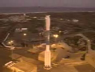
Jason-1 atop the Delta II Photo: Tom Shain
Jason-1 atop the Delta II Photo: Tom Shain
Water Vapor
Water Vapor
This artist's concept show Jason-3 over the Amazon.
Jason-3 over the Amazon