NASA
Jet Propulsion Laboratory
California Institute of Technology
Skip Navigation
Ocean Surface Topography from Space
Stay Connected
menu
close modal
Resources
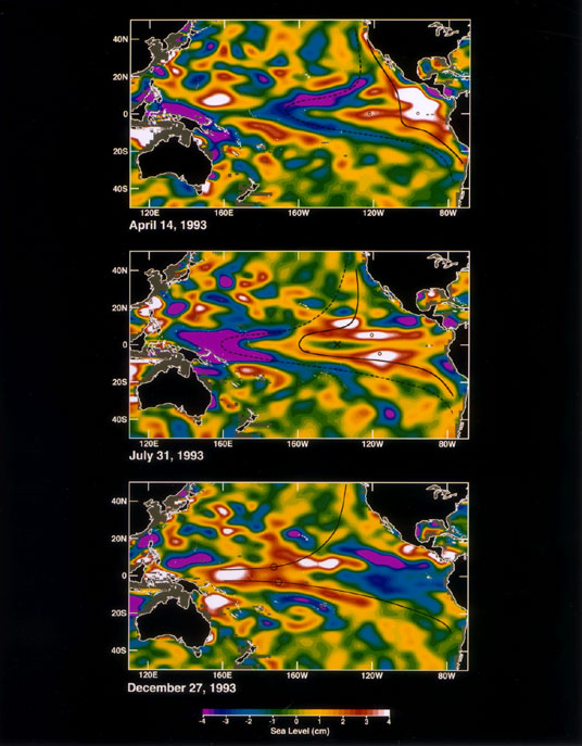
Sea Level
Published:
September 13, 2010
Sea Level
ENLARGE
Related
Jason-1 DORIS
Jason-1 DORIS
Ionospheric Total Electron Content
Ionospheric Total Electron Content
Spacecraft processing
Sentinel-6 Michael Freilich spacecraft processing
TOPEX/Poseidon Mission to Planet Earth
TOPEX/Poseidon Mission to Planet Earth
Radiometer Installation Team - April 2007
Radiometer Installation Team - April 2007
Jason-1 launch images
Jason-1 launch images
Jason-1 LRA
Jason-1 LRA
Jason-1: First Image
Jason-1: First Image
Jason-3
Jason-3
High Resolution Jason-1 launch images
High Resolution Jason-1 launch images
Jason-1: LRA instrument
Jason-1: LRA instrument
El Niño is characterized by unusually warm ocean temperatures in the eastern equatorial Pacific. The warmer water associated with El Niño displaces colder water in the upper layer of the ocean caus...
Sea Surface Height Anomaly, 2014-2016
This artist's concept show Jason-3 over France.
Jason-3 over France
TOPEX/Poseidon DORIS
TOPEX/Poseidon DORIS
OSTM/Jason-2 Artist's Concept
OSTM/Jason-2 Artist's Concept
Inside half of the Delta Clam shell faring
Inside half of the Delta Clam shell faring
In this illustration, the Sentinel-6 Michael Freilich spacecraft - the world's latest sea-level satellite - orbits Earth with its deployable solar panels extended.
Sentinel-6 Michael Freilich Satellite Orbits Earth (Illustration)
OSTM/Jason-2 Radiometer Antenna
OSTM/Jason-2 Radiometer Antenna
Wave Height
Wave Height
Launch preparations are progressing! (11/21/01) Photos: Stacy Mitchell of John Hopkins APL/TIMED project
Launch preparations are progressing! (11/21/01) Photos: Stacy Mitchell of John Hopkins APL/TIMED project
OSTM/Jason-2 Spacecraft
OSTM/Jason-2 Spacecraft
Jason-1 Radiometer
Jason-1 Radiometer
Jason-1 Artists Concept
Jason-1 Artists Concept
Headed for Orbit!
Headed for Orbit!
Launch preparations are progressing! (11/21/01) Photos: Stacy Mitchell of John Hopkins APL/TIMED project
Launch preparations are progressing! (11/21/01) Photos: Stacy Mitchell of John Hopkins APL/TIMED project