Understanding Climate
The Spherical Shape of the Earth
Because the Earth is a sphere, the surface gets much more intense sunlight (heat) at the equator than at the poles. During the equinox (the time of year when the amount of daylight and nighttime are approximately equal), the Sun passes directly overhead at noon on the equator. On the same day, at 60°N (the latitude of Anchorage, Alaska, or Oslo, Norway, or St. Petersburg, Russia), the Sun rises no higher than 30° above the horizon at noon and heats a given parcel of ground with only a half the intensity as at the equator. At the poles, the Sun appears to sit on the horizon for periods upwards of 24 hours, and its rays skim mostly horizontally over the surface.
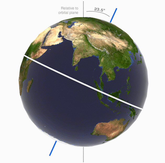
The 23.5° tilt of the axis means a substantial annual shift of sun angle. The June sun in San Francisco (or Wichita or Norfolk) is as high as the March sun in Guatemala City, while the December sun in San Francisco (or Wichita or Norfolk) is no higher than the March sun in Anchorage, Alaska. During the course of a year, a temperate-zone location can be said to enjoy tropical heat in the summer and to suffer arctic cold in winter.
The distribution of heat around the globe, and through the year, coupled with the physical properties of air, produce a distinctive pattern of climatic zones.
Climatic Zones
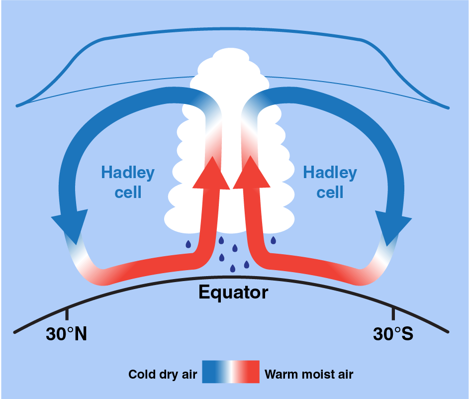
The Sun heats the ground or ocean surface most intensely in the tropical zone. The heated air rises, and as it rises, it cools, and as it cools it dumps its moisture as rain. This belt of converging air masses (called the doldrums due to low air and water circulation sometimes causing sail-powered ships to struggle to escape the region) includes some of the rainiest areas on Earth. The cooled, now drier air is forced by continuously rising air to move out of the way, and so it moves towards the temperate latitudes.
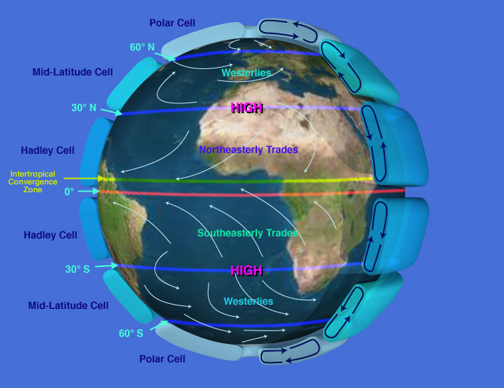
Such air from the tropics meets air moving down from the poles at about 30° N and S (sometimes called the horse latitudes) where it settles. Here the sinking air compresses, warms, and absorbs moisture from the surface. This is why Earth's desert belts lie in the horse latitudes. This warm, dry air is displaced by more sinking air and so some of it returns back to the equatorial zone, and some returns to the poles. Such cycling air between low and mid-latitudes defines an atmospheric cell. H
A similar cell forms between the horse latitudes and the stormy polar fronts at 60° N and 60° S, where warm temperate air moving polewards meets very cold air rolling down from the pole. The lighter warm air is forced to rise over the denser cold air, which chills it and forces precipitation. From this polar front, air returns both equatorwards and polewards. Air immediately over the pole sinks. While it is not warm, it is extremely dry (only centimeters of snow every year). From the poles, air within the polar cap streams back towards the polar front.
Thus, six belt-like atmospheric cells circulate air from equator to pole (and back) and establish patterns of climate over the planet. The cells are also characterized by specific patterns of wind flow, a function of the Coriolis Effect generated by the spin of the Earth. In the temperate zone between the horse latitudes and the polar front, the prevailing westerlies dominate air circulation. In the tropics, the easterly trade winds dominate. Winds around the poles are also easterly.
Movement of Earth through Space
The 24-hour-per-day spin of Earth accounts for the Coriolis Effect, Earth is 40,000 kilometers (24,900 miles) around at its widest part, the equator. Because it spins on its axis once in 24 hours, a point on Earth's equator is traveling about 1,700 km per hour (1,000 miles per hour) relative to its axis. But the closer you get to the poles, the smaller the track a point takes in its daily rotation. At 60° North or South latitude, the track is only half the distance that it is at the equator, and so a point travels only half as fast. Air (or water) moving from high latitudes to low then tends to lag, and a person on the surface would feel a wind blowing out of the east. On the other hand, air moving from low latitudes to high is deflected westwards. This also means that moving air or water is deflected to the right in the northern hemisphere, and to the left in the southern hemisphere.

Because of this Coriolis Effect, air rushing into a region of low pressure will turn into a counterclockwise cyclone in the northern hemisphere and a clockwise one in the southern hemisphere. (Contrary to popular belief, the Coriolis Effect does not determine the direction water swirls down a drain--the scale is just too small.) Air streaming out of high-pressure systems will also be deflected into clockwise anticyclones in the north and counterclockwise ones in the south.
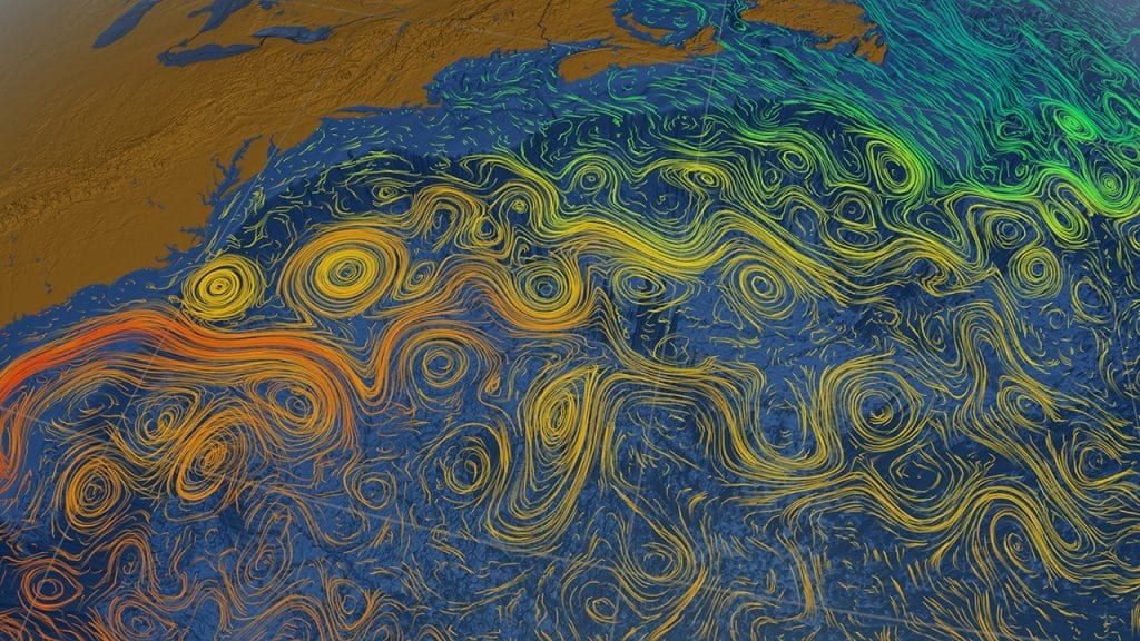
Ocean currents circulate in gyres, huge clockwise-running currents in the North Pacific and North Atlantic, and counterclockwise-running currents in the South Pacific, South Atlantic, and Indian Oceans. The direction of flow in smaller eddies is also determined by the Coriolis Effect.