Why Study the Ocean?
By distributing heat and moisture around the globe, the ocean is a driving force for Earth's weather. The weather determines not just what you'll wear to work in the week ahead – but also whether the wheat crop in Nebraska will get enough rain to mature, whether the snow pack in the Sierras will be adequate to satisfy Southern California's water needs, whether the hurricane season in the Atlantic will be feeble or fierce, or whether El Niño will impact the Eastern Pacific anchovy fisheries. Long-term weather patterns influence water and food supply, trade shipments, and property values. The ocean can even foster the growth of civilizations, or kill them off. You can't escape the weather, or even change it – but being able to predict its caprice makes its impact manageable. And only by understanding the dynamics of the Earth's ocean can we begin to predict its impacts on our societies.

The ocean also has a significant influence on global climate. The ocean covers 70% of the Earth’s surface but has absorbed more than 93% of the excess heat from greenhouse gas emissions since the 1970s. This great reservoir continuously exchanges heat, moisture, and carbon dioxide with the atmosphere, driving our weather patterns and influencing the slow, subtle changes in our climate. The ocean influences climate by: absorbing solar radiation and releasing heat needed to drive atmospheric circulation, releasing aerosols that influence cloud cover, providing most of the water that falls on land as rain, and absorbing carbon dioxide from the atmosphere and storing it for years to millions of years.
Ocean Surface Topography
Only from space can we observe the height of our vast ocean on a global scale and monitor critical changes in ocean currents and heat storage. Continuous data from satellites like TOPEX/Poseidon, Jason-1, OSTM/Jason-2, and Jason-3 help us understand and foresee the effects of the changing oceans on our climate and on far-reaching climate events such as El Niño and La Niña.
How can we measure and track changes in the oceanic heat budget? We need to know both ocean currents and heat storage of the ocean. Like winds blow around the highs and lows of atmospheric pressure, ocean currents flow around highs and lows of oceanic pressure. These can be determined from the height of the sea surface, also known as ocean surface topography. Ocean current velocity can thus be computed from the slope of the ocean surface. Furthermore, as water heats up, it expands, and as it cools, it contracts, affecting the height of sea surface as well. Measuring ocean surface topography thus gives the required information for studying global ocean circulation and the ocean’s heat budget. Consistent measuring of the ocean surface to maintain a database of ocean surface topography can help predict short-term changes in weather and longer-term patterns of climate.
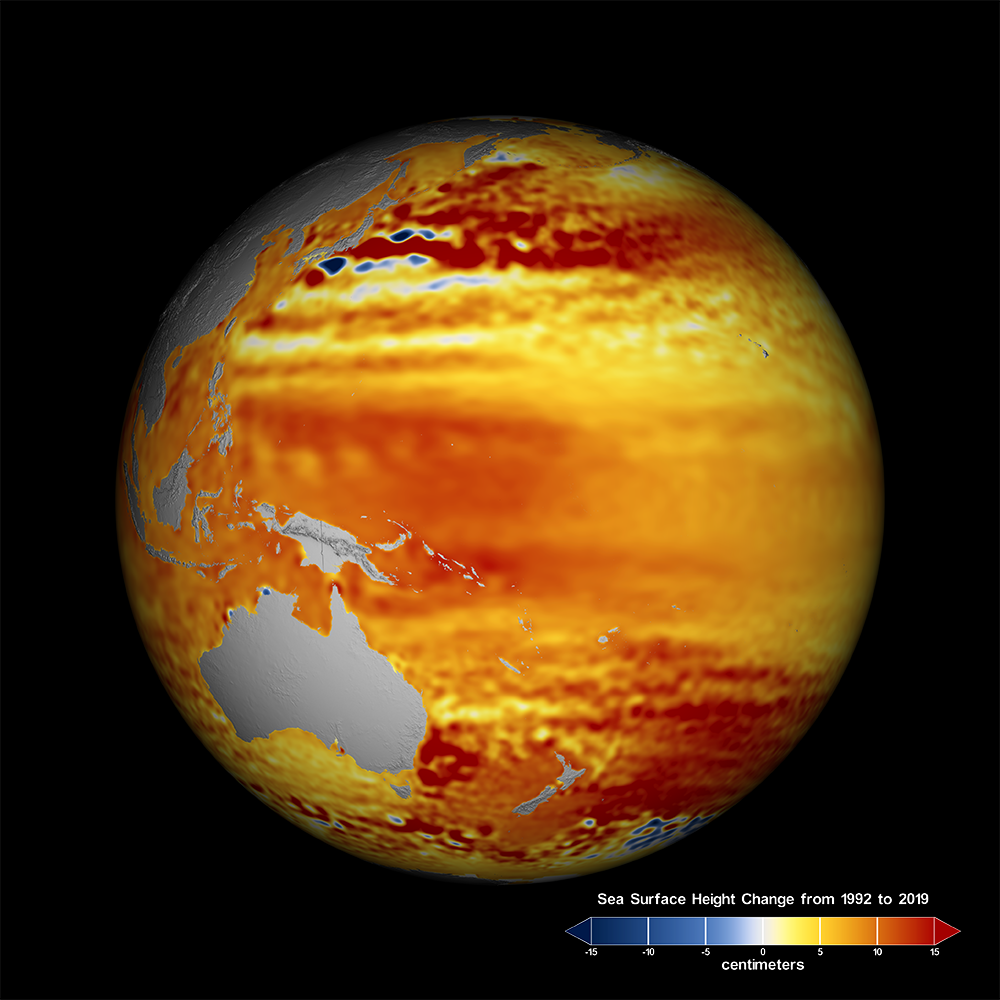
Since 1992, NASA, NOAA and our European partners have been tracking global ocean surface topography with joint ocean altimeter satellite missions from an orbit 1336 km (830.2 miles) above the ocean surface. The spacecrafts' radar altimeters measure the precise distance between the satellite and sea surface. The round-trip travel time of microwave pulses sent from the spacecraft to the sea surface and bounced back to the spacecraft provides data indicating sea surface height and the topography of the ocean surface. The precise altitude of the satellite is determined by a sophisticated estimation procedure based on instrument systems onboard the satellite and a network of ground receivers across the globe. The details of the shape of the returned radar pulses also give information on wind speed and the wave height. Ocean altimeter missions monitor large-scale features like Rossby and Kelvin waves, track El Niño's, like the large events of 1997-1998 and 2015-2016, and explore long-term changes such as the Pacific Decadal Oscillation.
The high accuracy of these measurements has made satellite altimetry an efficient method for monitoring the variation of global mean sea level in relation to global climate change. TOPEX/Poseidon (1992-2006) was joined in 2001, and later replaced by Jason-1 (2001-2013) , which continued to build the database. The GRACE (the Gravity Recovery and Climate Experiment) mission (2002-2017), helped to refine global measurements, increasing the utility of all previous altimetry data. The Ocean Surface Topography Mission on the Jason-2 satellite (OSTM/Jason-2), launched in June 2008, took ocean surface topography measurements into an operational mode for continued climate forecasting research, as well as scientific and industrial applications. Designed to operate for three to five years, NASA and its mission partners made the decision to end the mission on October 1, 2019 after detecting deterioration in the spacecraft's power system.
The story doesn’t end there. Jason-3 launched on January 17, 2016 to help continue U.S.-European satellite measurements of global ocean height changes. It is critical to have an overlap between the satellites to allow scientists to precisely calibrate instruments on the new satellite. GRACE Follow-On, launched on May 22, 2018, has continued the record of regional variations in gravity, telling us about changes in glaciers, ground water, sea levels and the health of our planet as a whole.
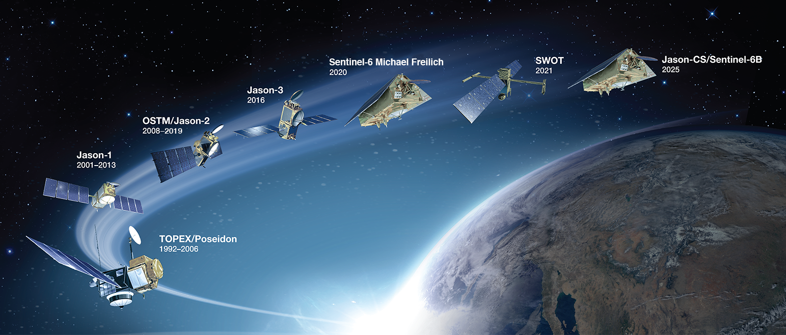
Due to the importance of a long-term record of sea level, Jason Continuity of Service spacecraft (Sentinel-6 Michael Freilich and Sentinel-6B) are on the horizon to guarantee adequate overlap with Jason-3 to obtain high-precision sea surface height measurements. Sentinel-6 Michael Freilich is scheduled to launch in November of 2020, while Sentinel-6B will head to space in 2025. In addition, the Sentinel-6 satellites will also include a Global Navigation Satellite System - Radio Occultation (GNSS-RO) instrument. The GNSS-RO measurements will provide information on atmospheric pressure, temperature and water vapor. The radio occultation data are important to address the needs of meteorological and climate users. Even more exciting, the Sentinel-6 satellites will offer better insights into changes in coastal regions.