News | May 29, 2014
Probing and Searching the Ocean Depths from Space
Satellite altimetry was in the limelight again this week. But not for the reason you might think. Satellites like TOPEX/Poseidon, Jason-1 and Jason-2 have been measuring the shape of the ocean surface from space since 1992. But this week, Walter Smith and Karen Marks reminded us that satellite altimeters also tell us about the sea floor in places where depths have never been measured.
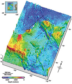
This image shows a map of the sea floor depth in an area of the Indian Ocean where the search for the missing Malaysian Airlines Flight MH370 is being carried out. Depths in this region range from a few hundred meters to more than 7,000 meters. The pull of gravity from underwater mountains and rises help to shape the ocean surface. Maps of the surface are combined with the few available depth soundings from ships to estimate the depth of the sea floor. Recent measurements by new satellites such as CryoSat-II, and Jason-1 during its final year of operations, helped make this the most accurate map of the sea floor in this region to date.
During the last 13 months of its mission, the NASA/CNES Jason-1 satellite was operated in a new orbit designed specifically to help with estimates of the shape of the sea floor. The 406-day repeating orbit made for a very tightly spaced ground track, which is key for improving such estimates.
These new maps reveal in amazing detail an underwater terrain of complex ridges and great plains. Before ocean altimetry, vast areas of the ocean floor were unknown, but these altimetry-derived maps are providing fascinating views of the ocean floor and vastly improve our capability to search for and recover objects on the sea floor.