News | March 10, 1999
La Niña hangs on

The cold pool of water in the Pacific known as "La Niña" still persists, although it is slowly weakening, according to scientists studying new data from the U.S.-French TOPEX/Poseidon satellite.
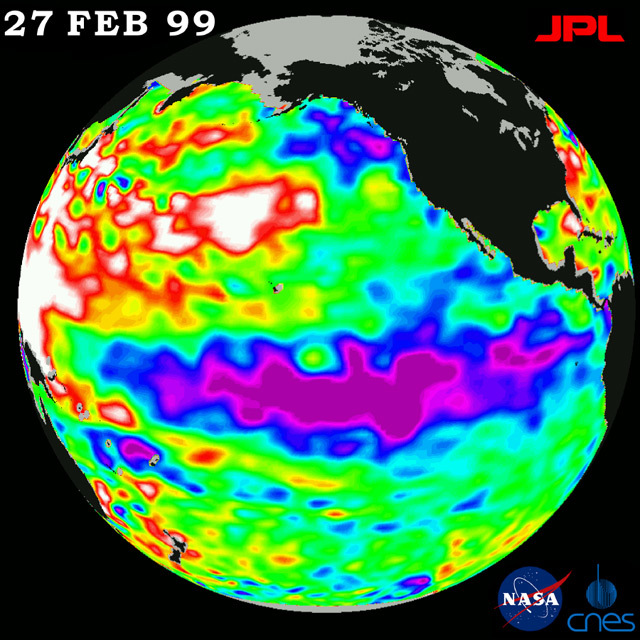
It shows sea-surface height on February 27, 1999 relative to normal ocean conditions, reflecting the heat content of the ocean.
The low sea level or cold pool of water along the equator (shown in purple and blue), commonly referred to as La Niña, still dominates the equatorial Pacific Ocean. This La Niña, which first appeared in May through June 1998, still persists, although it is slowly weakening, scientists say. Given its persistence and present strength, the ocean cooling trend is expected to continue to exert a strong influence on global climate systems throughout the spring and into the early summer. This situation is similar to the 1997-1998 El Niño, which extended into early summer 1998.
The world's oceans are the great reservoirs of heat that influence global climate because they can cool or heat the atmosphere above. This transfer of heat drives weather patterns across both land and sea. La Niña provides a physical link connecting the large, slow changes in the ocean with predictable changes in day-to-day weather.
"La Niña shifts the high-altitude weather highway known as the 'jet stream,'" said Dr. William Patzert, an oceanographer at NASA's Jet Propulsion Laboratory. "It funnels storm tracks to the Pacific Northwest, which has resulted in heavy rainfall and lots of snow in that region so far, as well as the upper Midwest. Much of the Southwest, by contrast, has been shielded from stormy weather and, as a result, has received significantly less precipitation than normal to date.
"This year's La Niña was average in its intensity, but at its peak, it was associated with a 15- to- 20-centimeter deep trough (6 to 8 inches) in the central tropical Pacific," Patzert said. "The depression was correlated with a 2- to- 3-degree Centigrade (about 3.5 to 5.5 degrees Fahrenheit) dip in normal ocean surface temperatures."
The image also shows that the very large, unusual area of higher or warmer water (shown here in red and white) in the western Pacific Ocean, from the tropics to the Gulf of Alaska, continues to expand. Although the appearance of this feature is not fully understood, it is recognized as influential to overall weather and climate.
The white areas in the image indicate that the sea-surface height is between 14 and 32 centimeters (6 to 13 inches) above normal; in the red areas, sea-surface height is about 10 centimeters (4 inches) above normal. The green areas indicate normal conditions. The purple areas are between 14 to 18 centimeters (6 to 7 inches) below normal, and the blue areas are between 5 to 13 centimeters (2 to 5 inches) below normal.
The TOPEX/Poseidon mission is managed by the Jet Propulsion Laboratory for NASA's Office of Earth Science, Washington, DC. JPL is a division of the California Institute of Technology, Pasadena, CA.
For more information, please visit the TOPEX/Poseidon project web page at http://topex-www.jpl.nasa.gov/


