FOAM: From Ocean to inland waters Altimetry Monitoring
Author:
Pascal Bonnefond - (Observatoire de Paris - SYRTE)
Co-Investigator(s):
Exertier, Pierre (UMR 7329 – GEOAZUR)
Laurain, Olivier (UMR 7329 – GEOAZUR)
Allain, Damien (UMR 5566 – CNES/LEGOS)
Bergé-Nguyen, Muriel (UMR 5566 – CNES/LEGOS)
Calmant, Stéphane (UMR 5566 – IRD/LEGOS)
Crétaux, Jean-François (UMR 5566 – CNES/LEGOS)
Lyard, Florent (UMR 5566 – LEGOS)
Testut, Laurent (UMR 5566 – LEGOS)
Bonnet, Marie-Paule (UMR 5563 – GET)
Darrozes, José (UMR 5563 – GET)
Frappart, Frédéric (UMR 5563 – GET)
Perosanz, Félix (UMR 5563 – CNES/GET)
Santamaría-Gómez, Alvaro (UMR 5563 – GET)
Ramillien, Guillaume (UMR 5563 – GET)
Seyler, Frédérique (UMR – ESPACE-DEV)
Ballu, Valérie (UMR UMR 7266 - LIENSs)
Bertin, Xavier (UMR UMR 7266 - LIENSs)
Poirier, Etienne (UMR UMR 7266 - LIENSs)
Brachet, Cédric (DT INSU)
Calzas, Michel (DT INSU)
Drezen, Christine (DT INSU)
Guillot, Antoine (DT INSU)
Mercier, Flavien (CNES)
Cancet, Mathilde (NOVELTIS)
Schaeffer, Philippe (CLS)
Abstract:
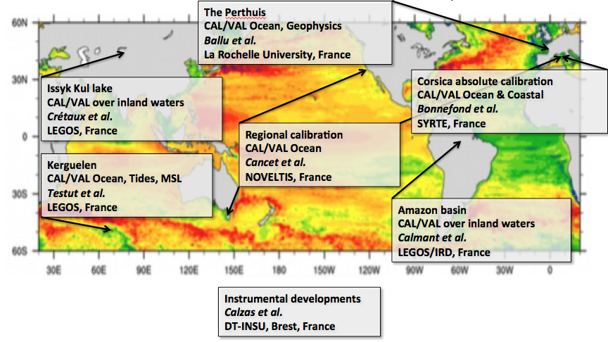
In collaboration with the CNES and NASA oceanographic projects (T/P and Jason), the OCA has developed a verification site in Corsica since 1996 and LEGOS installed sites in Kerguelen in 1993 and at Vanuatu in 1999 for oceanic validation and at Lake Issykul and along the Amazon river for continental waters. More recently, new coastal sites in France (île d’Aix and Pertuis Charentais, Arcachon Bay, Gironde Estuary) have been developed to deal with the littoral context. CALibration/VALidation embraces a wide variety of activities: interpretation of information from internal-calibration modes of the sensors, determination of the algorithm performing best in picking up the range in the radar echoes in various contexts, validation of the fully corrected estimates of the heights, whether it is sea level or inland water level, using in situ data. Today, Corsica is, like the Harvest platform (NASA side), an operating calibration site able to support a continuous monitoring with a high level of accuracy: a “point calibration” which yields instantaneous bias estimates with a 10-day repeatability of around 30 mm (standard deviation) and mean errors of 3-4 mm (standard error). The inland sites are also unique in the scientific community. They provide the only estimates of altimeter range bias and assessment of geophysical corrections for non-oceanic retracking algorithms commonly used for continental waters or for ranges issued from ocean-like waveforms in a context of very low sea-state bias, as it is frequently encountered over lakes.
In-situ calibration of altimetric height (Sea Surface Height for ocean surfaces) is usually done at the vertical of a dedicated CAL/VAL site, by direct comparison of the altimetric data with in-situ data. This configuration leads to better handling of the differences observed in the altimetric measurement system at the global scale: the Geographically Correlated Errors at regional (orbit, sea state bias, atmospheric corrections…) and local scales (geodetic systematic errors, land contamination for the instruments, e.g. the radiometer, land contamination for the radar echoes, e.g. tracking/retracking concerns, geophysical corrections). In order to increase statistically the sea surface bias estimation but also to cover larger areas, we extend the calibration opportunities by using, not only over-flying passes, but also satellite passes located far away from the CAL/VAL site (few hundreds of kilometers). This CAL/VAL method has been developed since 2003 and validated on the Corsica, Harvest and Bass Strait facilities for the Jason-2, Envisat and SARAL/AltiKa missions. With these offshore calibrations, two main effects interfere in the SSH bias determination: the geoid slope and the ocean dynamics. In order to improve these two components, the FOAM project will investigate high-resolution geoid and ocean numerical models notably in preparation of the SWOT mission.
We also intend to continue and ensure the experiments already conducted through the FOAM project (2007-2011 and 2012-2016), funded in the framework of the Jason missions (but thought as a multi-mission approach), at various sites (Corsica, Kerguelen, île d’Aix, Pertuis Charentais, Arcachon Bay, Gironde Estuary, lakes and rivers…) where the local conditions are different from each other and where permanent instruments and infrastructures already exist and have to be reinforced. The FOAM project has been the place of a reflection about CAL/VAL methodologies and in particular about building dedicated instruments. This last point, which insures consistent procedures and equipment among all the team members is crucial for a multi-mission CAL/VAL approach. One of the achievements in term of instrument development during the previous FOAM period (2012-2016) was the towable floating blanket equipped with a GNSS (CalNaGeo) that permits to map water surface heights (ocean and inland waters) without any dependency of the waterline as a function of velocity or sea state.
The proposed CAL/VAL activities are thus focused not only on the important continuity between past, present and future missions but also on the reliability between offshore, coastal and inland altimetric measurement. In addition, we enter a new era of altimetry (SAR and wide swath altimetry) and our group will take a particular focus on the new measurement systems and their reliability with the past ones (LRM). Our objective is to aggregate the past and present effort and expertise of several groups, in order to notably establish a homogeneous and optimized network of calibration sites geographically distributed for more robust characterization of the existing and future radar altimeter system instrument biases and their drift.