High Resolution Altimeter Iceberg Distribution (HRALTIBERG)
Author:
Jean Tournadre - (LOS - IFREMER)
Co-Investigator(s):
Fanny Girard-Ardhuin (IFREMER)
Frédérique Remy (LEGOS)
Abstract:

Interest in icebergs has been growing in recent years as they may account for a significant part of the freshwater flux in the southern ocean, and because they have been shown to transport nutriments (in particular labile iron) that could have a significant impact on ocean primary productivity . It was also demonstrated that small iceberg can have a significant impact on sea state modelling. Small icebergs, at least in open water, have a significant signature in the noise part of high resolution (HR) altimeter waveforms that can be easily detected. The analysis of altimeter HR waveforms over the southern ocean enables the detection and analysis of small iceberg distribution. Under assumptions on freeboard height and on ice backscatter, the iceberg surface and thus the ice volume can be inferred from the icebergs backscatter and range.
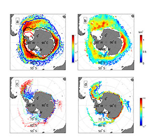
The ALTIBERG 1 and 2 projects used these altimeter detection capabilities to analyze the characteristics of small icebergs (<10km2) and to estimate the volume of large ones (>400 km2). The icebergs characteristics database were used to analyze the evolution of the volume of ice distribution in the Southern Ocean from 1992 to present for both small and large icebergs on a monthly and 100x100 km2 resolution. Combining the large and small icebergs database a first estimate of the overall distribution of icebergs size from 0.1 to 10000 km2 was also computed. This distribution is a power law of -3/2 slope characteristic of fragile fragmentation. This gives a first insight into the fragmentation process of icebergs and into the transfer of ice from large to small icebergs.
Within the OSTST SARAL/Altika proposal, the iceberg and sea ice studies will focus on the detection and estimation of iceberg volume around Greenland by creating an iceberg database for all past and existing altimeters. Altika, which has better detection capabilities because of its smaller footprint and higher along track resolution, will serve as the basis for inter-calibration between the different altimeters. In parallel, the evolution of large icebergs surface will be investigated by combining AltiKa and measurements at Ka and Ku band by precipitation radars on board the Global Precipitation Mission. The evolution of backscatter will then be analyzed (in conjunction with environmental parameters, Air and sea temperature, wind..) to estimate the evolution of the icebergs surface: snow cover, liquid ice,.. in relation with basal melting.
The present HRALTI project is in direct continuity with the ALTIBERG projects. This year has seen the launches of Jason-3 and Sentinel-3. At present, six altimeters, HY2A, Cryosat, Jason2, Altika, Jason-3 and Sentinel-3, are thus currently sampling the globe giving a very unique opportunity to improve the actual monthly and 100 km resolutions of the small and large iceberg volume fields possibly down to weekly and 50x50 km2 resolutions. These better temporal and spatial resolutions are important first to improve our knowledge of the transport of ice around Antarctica, but also for a better wave modeling of the Southern Ocean, a better validation of southern ocean circulation or a better forcing of the OGCM.
To achieve these resolution improvements, it is first necessary to adapt and validate the detection and analysis method to the two new altimeters, in particular S3 whose altimeter has SAR capabilities, to increase the existing ALTIBERG small iceberg database. The method already developed for SAR altimetry on Cryosat will be further tested and a careful inter-calibration between Cryosat and S3 will be conducted. Secondly, the 6 altimeters will be inter-calibrated using backscatter and iceberg size distributions. The C/Ku band dual frequency capabilities of J2, J3, S3 and HY2A that have not yet been used, will be investigated to further improve the detection and the estimation of the icebergs characteristics and to better describe the icebergs surface (in relation with the SARAL project).
In parallel, the estimation of the free-board of large icebergs combining icebergs tracks from the National Ice Center and the Brigham Young University will be automate to cope with the increased number of altimeters. This development will also try to detect icebergs large enough to give a detectable change of height but not enough to be part of the NIC data base (16km in length).
Expected results of the study are firstly an improved description of the southern ocean icebergs distribution in the continuity of ALTIBERG that will be of importance to better understand the melting and fragmentation processes of iceberg and secondly the distribution of iceberg in the northern hemisphere (around Greenland mainly). Indeed, the extent of the northern hemisphere iceberg distribution is small and the density of icebergs is low compared to the southern ones, six altimeters provide data at a time and space resolution high enough to allow the estimate of a pertinent iceberg distribution.
