SWANS: Surface Winds from Altimetry at Near Shore
Author:
Frédéric Frappart - (LEGOS)
Co-Investigator(s):
Orlando Astudillo (LEGOS/CEAZA)
Serena Illig (LEGOS)
Florence Birol (LEGOS)
Katerina Goubanova (LEGOS/CEAZA)
Marcel Ramos (UCN/CEAZA)
Luis Bravo (UCN)
José Rutllant (CEAZA)
Marc Mallet (CNRM)
Abderrahim Bentamy (IFREMER)
Chris Reason (University of Cape Town)
Ivonne Montés (IGP)
Lionel Renault (UCLA)
Denis Bourras (MIO)
Abstract:
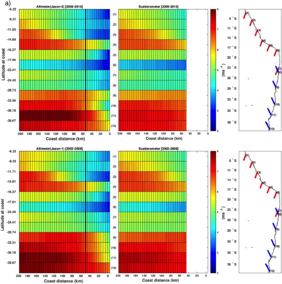
Surface winds intensity can be retrieved from radar altimetry backscattering coefficients using empirical formulas. They affect the amplitude of the return pulse echo as the sea surface becomes rougher so that the number of specularly reflecting faces decreases and more energy is scattered back in off-nadir directions with increasing wind speed. This leads to a decrease in the amplitude of the mean backscattered power, which can be related to the surface wind speed. Surface wind speed intensity estimates are provided in the Geophysical Data Records made available by the space agencies. Due to inherent limitations of the altimetry missions (low spatial and temporal resolutions) for addressing synoptic-scale, they are not as commonly used as surface winds from scatterometers. However, the narrower altimeter footprint allows resolving the 25-50-km fringe along the coast, thus improving near-shore wind retrievals with respect to scatterometer capability. In this project we propose to estimate and document the altimetry-derived coastal surface wind vectors along the coasts of the continents with a focus on Eastern Boundary Upwelling systems (EBUS) where the on-shore decrease of the wind amplitude can produce significant impact on the regional oceanic circulation through Ekman dynamics. Specific goals include:
- to perform an extensive validation of the altimetry-based surface winds using in situ wind data from buoys of the National Data Buoy Center (NDBC) and ship-based measurements from fisheries fleet (when available) in the four major upwelling regions - Peru-Chile (5–40° S; 70–100° W), California (20–50° N; 105–140° W), Benguela (10–40° S; 0–30° E), Canary (10–45° N; 40–5° W). The validation work will be guided by the results of regional atmospheric model simulations with the Weather Research and Forecasting (WRF) model that will serve as a material for the interpretation of the data in low-coverage in situ data areas and for process-oriented studies.
- to provide to the scientific community a comprehensive datasets of through the Centre de Topographie des Océans et de l’Hydrosphère (CTOH)/Aviso+ database that contain vector components and the associated wind stress components of the altimeter-derived wind speed estimated taking into account the orientations of the coast and the altimeter track and external information on wind direction from either scatterometry or regional models, the wind stress based on the altimetry-derived vectorial wind speed, and estimate of Ekman pumping vertical velocity and the Ekman transport for all the missions from ERS-1 to Sentinel-6/Jason-CS and SWOT to be launched in 2020. Assessment of the quality of the products for the different missions will be performed against scatterometers-based 10m surface winds offshore and against regional meteorological model outputs and in situ data such as wind data from buoys from National Data Buoy Center (NDBC) when available, and also ship based measurements from fisheries fleet.
- to provide estimates of latent (evaporation) and sensible heat flux along the altimeter tracks in coastal areas combining satellite SST and specific air humidity and altimetric wind speed using the bulk formula. Validation of these new products will be performed against scatterometer-based latent and sensible heat fluxes over some offshore distance from the coast. Depending on the results, they will be integrated to the CTOH/Aviso+ database and made available to the scientific community.
- to perform process-oriented studies based on the experimentation with regional oceanic and atmospheric models in order to provide material for the interpretation of the altimetric data and better understand the role of air-sea interactions in shaping the low-level atmospheric circulation in the Humboldt and Benguela systems.
References: Astudillo, O., B. Dewitte, M. Mallet, F. Frappart, J. Ruttlant, M. Ramos, L. Bravos, K. Goubanova and S. Illig, 2017: Surface winds off Peru-Chile: Observing closer to the coast from radar altimetry, Journal of Remote Sensing of Environment, in press.