Alti-ETAO - Characterization and analysis of circulation and mesoscale dynamics in the Eastern Tropical Atlantic Ocean using altimetry data
Author:
Isabelle Dadou - (LEGOS)
Co-Principle Investigator(s):
Yves Morel (LEGOS)
Gaël Alory (LEGOS)
Co-Investigator(s):
Alexis Chaigneau (LEGOS)
Julien Jouanno (LEGOS)
Frédéric Marin (LEGOS)
Marie-Hélène Radenac (LEGOS)
Florent Lyard (LEGOS)
Bernard Bourles (LEGOS)
Stéphane Calmant (LEGOS)
Abstract:
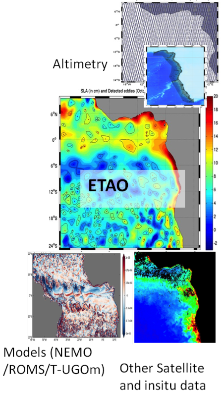
The main objective of this project is to use long-term time series of altimetry measurements, both the single-mission along track data (T/P, ERS, JASON 1, 2 and 3, AltiKa, Sentinel3, etc.) and multi-mission gridded products, to study the dynamics of the Eastern Tropical Atlantic Ocean (ETAO, see Figure 1), especially at mesoscale (10 km-500 km) from intraseasonal to interannual timescales. This mesoscale activity in the ETAO is not well known and interacts with a broad range of processes such as the large-scale circulation, the equatorial waves and the near-coastal dynamics.
Combining altimetry data with other remotely sensed data such as surface winds (ERS, QuikSCAT, ASCAT), sea surface temperature (AVHRR, TMI,…), ocean color (SeaWiFS, MODIS/Aqua, MERIS, Sentinel3, GlobColour multi-mission product), Sea Surface Salinity (SSS from SMOS) and high-resolution numerical models, we will address the following issues in the ETAO region :
- Determine the main characteristics of the mesoscale activity (especially eddies) and investigate its role on the overlying atmosphere and the regional oceanic circulation, in particular for the transport from coastal regions to the open ocean;
- Examine how this mesoscale activity (forcing/formation, propagation, dissipation) is influenced by the large scale current variability (equatorial, tropical), the equatorial waves and the coastal dynamics (coastal currents, transient and permanent upwelling systems, trapped waves and internal tides).
We will also improve the coastal altimetry data with high frequency/space corrections for the ETAO. Furthermore, new diagnostics will be proposed on the structure of vortices and their impact on the large scale dynamics (also productivity), in particular combining altimetry with other observations (both satellite and in situ), some of which having already been successfully applied to other regions or numerical simulations. Numerical results from realistic high resolution models of the region, will serve as a virtual reality to test these diagnostics but also to identify their possible limitations and evaluate whether future wide swath altimetry observations (SWOT) can overcome these problems.