Validation, cross-calibration and performances of altimetry missions over ocean for mesoscale, coastal and climate applications
Author(s):
Michaël Ablain (CLS)
Co-Investigator(s):
Sabine Philipps (CLS)
Annabelle Ollivier (CLS)
Guillaume Valladeau(CLS)
Jean-François Legeais (CLS)
Pierre Prandi (CLS)
Yannice Faugere (CLS)
Sylvie Labroue (CLS)
Gérald Dibarboure (CLS)
Nicolas Picot (CNES)
Emilie Bronner (CNES)
Amandine Guillot (CNES)
Joël Dorandeu (MERCATOR OCEAN)
Abstract:
The main objective of the investigation is to take benefit of multi-mission altimetry and other sources of independent data to improve the altimetry performance assessment methods.
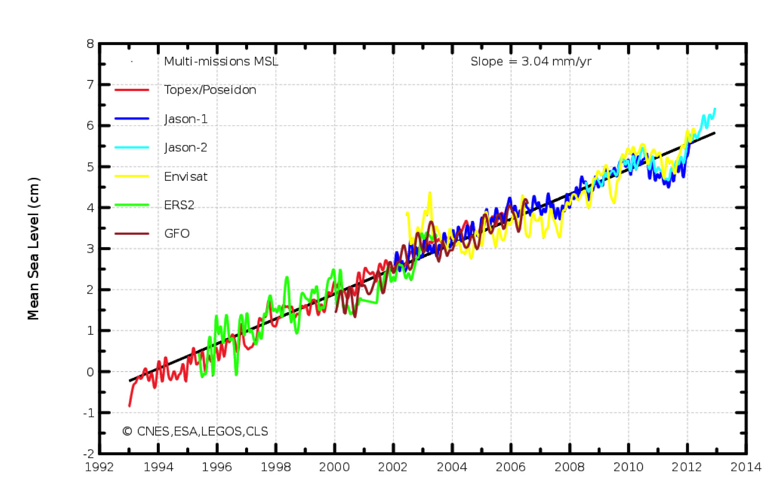
Satellite altimetry is now an essential source of data for oceanic signal studies. From the ERS and TOPEX/Poseidon (T/P) missions, it has been demonstrated that a continuous precise multi-mission altimeter dataset is mandatory for many scientific applications: mesoscale variability description (Le Traon and Morrow, 2001), seasonal / interannual signals determination (e.g. Chambers et al., 2000, Mc Carthy et al., 2000, Roemmich et al., 2007) and estimation of the Mean Sea Level (MSL) variations (e.g. Nerem et al., 1997, Cazenave et al., 1999, Cabannes et al., 2001, Lombard et al., 2006 among others).
Jason-1, Jason-2, ENVISAT still provide reliable high-quality data albeit not on their original ground track. If we add older datasets such as T/P, ERS-1&2 and GFO missions, an unprecedented ocean sampling of 65 years of cumulated data with up to 4 concurrent altimeters is available. The future altimetry missions (SARAL/AltiKa mission, Jason-3/OSTST, Sentinel-3,...) will provide a precious continuity of the sea-level observations for mesoscale, coastal or climate applications.
In order to continue to build an accurate altimetry data record, the validation and cross-calibration of these new altimetry missions is a crucial step. It is also a prerequisite for the use of multi-mission datasets in both delayed mode and near real time and for studies of long-term, low-frequency oceanic signals, or signal and error aliasing.
This analysis includes but is not limited to:
- Improvements of existing calibration and cross-calibration methods for present and future altimeter missions. Dedicated studies will be carried out to better estimate the altimeter system error budget, depending on the different contributions (instrument, orbit precision, geophysical corrections) and for different applications (e.g.: mesoscale studies, mean Sea Level estimations). Significant changes in cross-calibration algorithms will be able to use multiple reference missions in an operational framework, thanks to the POD accuracy provided by altimetry missions.
- Altimetry / In Situ systematic comparisons to validate the altimeter measurements. Tide gauge measurements but also temperature/salinity profiles and surface velocity data (drifters, moorings) will be used in inter-comparison methods to validate the signals derived from altimeter missions.
- Studies of low-frequency oceanic signals from altimeter long time series. Currently, more than 20 years of altimeter data are available, after precise assessment and cross-calibration, for studying decadal and low frequency signals. Comparisons between signals deduced from altimetry and signals from other sources of independent data (SST, In Situ, GOCE) will be carried out.