NASA
Jet Propulsion Laboratory
California Institute of Technology
Skip Navigation
Ocean Surface Topography from Space
Stay Connected
menu
close modal
Resources
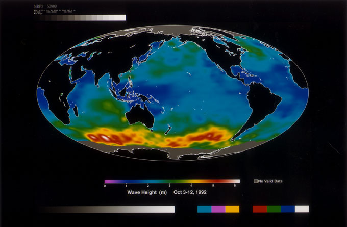
Wave Height
Published:
September 13, 2010
Wave Height
ENLARGE
Related
Variability of Ocean Dynamic Topography
Variability of Ocean Dynamic Topography
Launch preparations are progressing! (11/21/01) Photos: Stacy Mitchell of John Hopkins APL/TIMED project
Launch preparations are progressing! (11/21/01) Photos: Stacy Mitchell of John Hopkins APL/TIMED project
TOPEX/Poseidon Line Drawing
TOPEX/Poseidon Line Drawing
Jason-3 Ready for Launch
Jason-3 Ready for Launch
Radiometer Install - April 2007
Radiometer Install - April 2007
TOPEX/Poseidon over Earth
TOPEX/Poseidon over Earth
The Antonov cargo aircraft carrying the Sentinel-6 Michael Freilich satellite touches down on the runway at Vandenberg Air Force Base in California on Sept. 24, 2020.
Sentinel-6 Spacecraft Arrival/Offload
This artist's concept shows Jason-3 over the California coast.
Jason-3 over California
SpaceX Falcon 9 rocket with the Sentinel-6 Michael Freilich satellite is lifted to vertical at Space Launch Complex 4
Sentinel-6 on pad at SLC-4, VAFB
Launch preparations are progressing! (11/21/01) Photos: Stacy Mitchell of John Hopkins APL/TIMED project
Launch preparations are progressing! (11/21/01) Photos: Stacy Mitchell of John Hopkins APL/TIMED project
This visualization shows total sea level change between 1992 and 2019, based on data collected from the TOPEX/Poseidon, Jason-1, Jason-2, and Jason-3 satellites. Blue regions are where sea level ha...
27-year Sea Level Rise - TOPEX/JASON
These photos were taken during the Payload Attach Fitting (PAF) mating operation with Jason-1. (11/14/01) Photos: Scott Michel
These photos were taken during the Payload Attach Fitting (PAF) mating operation with Jason-1. (11/14/01) Photos: Scott Michel
The Sentinel-6 Michael Freilich satellite sits in front of a testing chamber where mission team members tested whether the spacecraft could endure the loud sounds it will encounter during launch.
Testing of Sentintel-6 Michael Freilich satellite
Whale Census and Habitat
Whale Census and Habitat
Radiometer Rework - April 2007
Radiometer Rework - April 2007
Applications of Spaceborne Altimetry
Applications of Spaceborne Altimetry
Jason-1 Launch - Artists Concept
Jason-1 Launch - Artists Concept
OSTM/Jason-2 GPSP
OSTM/Jason-2 GPSP
In this illustration, the Sentinel-6 Michael Freilich spacecraft - the world's latest sea-level satellite - orbits Earth with its deployable solar panels extended.
Sentinel-6 Michael Freilich Satellite Orbits Earth (Illustration)
Jason-3 on the Launch Pad
Jason-3 on the Launch Pad
Wind Speed
Wind Speed
This artist's concept show Jason-3 over the Amazon.
Jason-3 over the Amazon
These photos were taken during the Dual Payload Attach Fitting (DPAF) mating operation with Jason-1. (11/13/01) Photos: Scott Michel
These photos were taken during the Dual Payload Attach Fitting (DPAF) mating operation with Jason-1. (11/13/01) Photos: Scott Michel
Launch preparations are progressing! (11/21/01) Photos: Stacy Mitchell of John Hopkins APL/TIMED project
Launch preparations are progressing! (11/21/01) Photos: Stacy Mitchell of John Hopkins APL/TIMED project
El Niño is characterized by unusually warm ocean temperatures in the eastern equatorial Pacific. The warmer water associated with El Niño displaces colder water in the upper layer of the ocean caus...
Sea Surface Height Anomaly, 2014-2016